Are you curious about the recent seismic activity in New Jersey? The question “Why Was There An Earthquake In Nj?” is one that many are asking, and why.edu.vn is here to provide a detailed explanation. New Jersey earthquakes, though less frequent than in other regions, are a reality due to complex geological factors, including intraplate activity and the state’s unique geological composition.
We will explore the causes, the geological context, and what makes the Garden State susceptible to these events, while diving deep into seismic activity, geological faults, and earthquake preparedness. Let’s examine the science behind these tremors and understand why they occur.
1. What Causes Earthquakes in New Jersey?
Earthquakes in New Jersey are primarily caused by the movement of tectonic plates, even though the state is not located on a plate boundary. These are intraplate earthquakes, which occur within the interior of a tectonic plate rather than at its edge. Stresses build up over time within the plate due to various geological processes, and when these stresses exceed the strength of the rocks, they can rupture, causing an earthquake.
1.1 Intraplate Earthquakes Explained
Intraplate earthquakes are seismic events that occur within the interior of a tectonic plate, away from plate boundaries. Unlike interplate earthquakes, which are caused by the direct interaction of plates along their boundaries, intraplate earthquakes result from the accumulation and release of stress within the plate itself.
1.1.1 Stress Buildup
Stress within a tectonic plate can accumulate due to a variety of factors:
- Mantle Convection: The slow movement of the Earth’s mantle can exert stress on the overlying plate.
- Ridge Push: The force exerted by mid-ocean ridges as new crust is formed can push on the plates.
- Slab Pull: The sinking of old, dense oceanic crust at subduction zones can pull on the plates.
- Glacial Rebound: The Earth’s crust is still rebounding from the removal of ice sheets after the last ice age. This process can cause stress changes in the crust.
- Fault Reactivation: Ancient faults that formed millions of years ago can be reactivated by the accumulated stress.
1.1.2 Release of Stress
When the stress within the plate exceeds the strength of the rocks, a rupture occurs. This rupture propagates along a fault, releasing energy in the form of seismic waves. These waves travel through the Earth and cause the ground to shake.
1.1.3 Characteristics of Intraplate Earthquakes
Intraplate earthquakes tend to have several distinguishing characteristics:
- Lower Frequency: They occur less frequently than interplate earthquakes.
- Shallower Focal Depth: They tend to occur at shallower depths in the crust.
- Longer Duration: The shaking can last longer compared to interplate earthquakes of similar magnitude.
- Wider Area of Impact: The seismic waves can travel greater distances through the stable continental crust, resulting in a wider area of impact.
1.1.4 Examples of Intraplate Earthquakes
- New Madrid Seismic Zone (Central US): This is one of the most well-known intraplate seismic zones in the world.
- Eastern North America: The eastern part of North America experiences intraplate earthquakes, including those in New Jersey.
- Australia: The Australian continent is located within the Indo-Australian Plate and experiences intraplate earthquakes.
- India: The Indian subcontinent, located within the Indian Plate, also experiences intraplate earthquakes.
1.2 Geological Faults in New Jersey
New Jersey has several geological faults, with the Ramapo Fault being the most significant. These faults are fractures in the Earth’s crust where movement has occurred. While the Ramapo Fault is not as active as faults in California, it can still generate earthquakes.
1.2.1 The Ramapo Fault
The Ramapo Fault is a major geological fault that extends for approximately 185 miles (300 kilometers) from southeastern New York, through northern New Jersey, and into eastern Pennsylvania. It is part of a larger system of faults and fractures in the Earth’s crust.
1.2.1.1 Formation and Geological History
The Ramapo Fault was formed during the Precambrian Era, over 600 million years ago. It is associated with the Grenville Orogeny, a period of mountain building that created the ancient bedrock of the region. Over millions of years, the fault has been subjected to various geological processes, including periods of uplift, erosion, and sedimentation.
1.2.1.2 Characteristics
- Length: Approximately 185 miles (300 kilometers)
- Location: Southeastern New York, northern New Jersey, and eastern Pennsylvania
- Type: A complex system of faults and fractures
- Age: Formed during the Precambrian Era (over 600 million years ago)
1.2.1.3 Tectonic Setting
The Ramapo Fault is located within the Appalachian Orogen, a region of deformed rocks that were formed during the assembly of the supercontinent Pangaea. The fault is not located on a plate boundary but is an intraplate feature.
1.2.1.4 Seismic Activity
While the Ramapo Fault is not as active as faults in California, it is still capable of generating earthquakes. The fault is subject to stress from the movement of tectonic plates, and when this stress exceeds the strength of the rocks, it can rupture, causing an earthquake.
1.2.1.5 Recent Seismic Events
- April 5, 2024 Earthquake: A 4.8-magnitude earthquake centered near Whitehouse Station in Hunterdon County, New Jersey, was felt throughout the region.
- Aftershocks: Dozens of aftershocks have been reported since the April 5 earthquake, indicating continued activity along the fault.
- October 26, 2024 Earthquake: A 2.2-magnitude earthquake occurred near Califon in Hunterdon County.
1.2.1.6 Potential Hazards
The Ramapo Fault poses a potential hazard to the region, as it is capable of generating earthquakes that could cause damage to buildings, infrastructure, and the environment. The risk is relatively low compared to more active seismic zones, but it is still important to be aware of the potential for earthquakes.
1.2.1.7 Monitoring and Research
The Ramapo Fault is monitored by the U.S. Geological Survey (USGS) and other organizations. Scientists study the fault to better understand its behavior and to assess the risk of future earthquakes. Research includes:
- Seismic Monitoring: Installing seismometers to record earthquakes and track fault activity.
- Geological Mapping: Studying the geology of the fault zone to understand its structure and history.
- Stress Measurements: Measuring the stress in the rocks to assess the potential for future earthquakes.
1.2.1.8 Mitigation Measures
Mitigation measures can be taken to reduce the risk of earthquake damage in the region. These include:
- Building Codes: Implementing building codes that require structures to be designed to withstand earthquake forces.
- Retrofitting: Strengthening existing buildings to make them more resistant to earthquakes.
- Public Education: Educating the public about earthquake hazards and how to prepare for them.
- Emergency Planning: Developing emergency plans to respond to earthquakes and provide assistance to those affected.
1.2.1.9 Significance of the Ramapo Fault
The Ramapo Fault is an important geological feature that provides insights into the tectonic history of the eastern United States. While it is not as active as faults in California, it is still capable of generating earthquakes and poses a potential hazard to the region. By studying the fault and implementing mitigation measures, we can reduce the risk of earthquake damage and protect our communities.
1.3 Historical Seismic Activity
New Jersey has experienced several earthquakes throughout its history, although most have been relatively small. These historical events provide valuable data for understanding the region’s seismic patterns.
| Date | Location | Magnitude |
|---|---|---|
| April 5, 2024 | Near Whitehouse Station, Hunterdon County | 4.8 |
| Oct 26, 2024 | Near Califon, Hunterdon County | 2.2 |
| 1884 | New York City area | 5.2 |
1.4 Factors Influencing Earthquake Intensity
Several factors influence the intensity of earthquakes in New Jersey, including the magnitude of the quake, the depth of the focus, and the type of soil in the area.
1.4.1 Magnitude of the Quake
The magnitude of an earthquake is a measure of the energy released at its source. It is typically measured using the Richter scale or the moment magnitude scale. The larger the magnitude, the more intense the shaking will be.
1.4.2 Depth of the Focus
The focus of an earthquake is the point within the Earth where the rupture begins. The depth of the focus can affect the intensity of the shaking at the surface. Shallower earthquakes tend to produce more intense shaking than deeper earthquakes of the same magnitude.
1.4.3 Type of Soil
The type of soil in an area can also affect the intensity of earthquake shaking. Soft soils, such as those found in coastal areas, can amplify the shaking, while hard, dense soils tend to dampen it.
According to research from the Department of Civil and Environmental Engineering at Rutgers University in June 2024, soil composition in coastal regions of New Jersey amplifies seismic waves by up to 30%, increasing the risk of structural damage during earthquakes.
1.5 Human Activities
While natural geological processes are the primary cause of earthquakes, certain human activities can also contribute to seismic activity.
1.5.1 Fracking
Fracking, or hydraulic fracturing, is a technique used to extract oil and natural gas from shale rock. The process involves injecting high-pressure fluids into the rock to create fractures, which allows the oil and gas to flow more freely. In some cases, fracking has been linked to induced seismicity, or earthquakes that are caused by human activities.
1.5.2 Reservoir Impoundment
The construction of large dams and reservoirs can also induce seismicity. The weight of the water in the reservoir can change the stress on the underlying rocks, which can trigger earthquakes.
1.5.3 Mining
Mining activities, such as the extraction of coal or minerals, can also cause earthquakes. The removal of large amounts of rock can change the stress on the surrounding rocks, which can lead to instability and earthquakes.
1.6 Climate Change
Climate change can indirectly influence earthquake activity by altering the distribution of mass on the Earth’s surface.
1.6.1 Melting Glaciers
The melting of glaciers can reduce the weight on the Earth’s crust, which can cause the crust to rebound. This process can change the stress on faults and potentially trigger earthquakes.
1.6.2 Sea Level Rise
Sea level rise can increase the load on coastal areas, which can also change the stress on faults. Additionally, sea level rise can lead to erosion and landslides, which can destabilize the ground and increase the risk of earthquakes.
2. Why New Jersey Experiences Less Frequent Earthquakes Than Other Regions
New Jersey experiences fewer earthquakes compared to states like California because it is not located on a plate boundary. The state’s geological composition also plays a role in its lower seismic activity.
2.1 Tectonic Plate Boundaries
The Earth’s lithosphere is divided into several large and small tectonic plates that are constantly moving. Most earthquakes occur at the boundaries between these plates, where the plates interact with each other. These interactions can take several forms:
- Convergent Boundaries: Plates collide, and one plate may subduct beneath the other. This process can generate large earthquakes.
- Divergent Boundaries: Plates move apart, and new crust is formed. This process can also generate earthquakes, but they tend to be smaller than those at convergent boundaries.
- Transform Boundaries: Plates slide past each other horizontally. This process can generate large earthquakes, such as those along the San Andreas Fault in California.
2.2 New Jersey’s Geological Composition
The geology of New Jersey is characterized by a stable continental crust composed of ancient rocks. This type of crust tends to transmit seismic waves over longer distances, which means that earthquakes in New Jersey can be felt over a wider area than earthquakes in California.
2.3 Comparison with California
California is located on the boundary between the Pacific and North American plates. This boundary is characterized by frequent earthquakes, including some of the largest earthquakes ever recorded. New Jersey, on the other hand, is located far from any plate boundary, and its seismic activity is much lower.
| Feature | New Jersey | California |
|---|---|---|
| Plate Boundary | Intraplate | Interplate (Pacific and North American plates) |
| Geological Composition | Stable continental crust composed of ancient rocks | Complex geological setting with active faults |
| Seismic Activity | Lower frequency and intensity | Higher frequency and intensity |
| Faults | Ramapo Fault and other minor faults | San Andreas Fault and numerous other active faults |
| Earthquake History | Relatively few large earthquakes | Numerous large earthquakes, including the 1906 San Francisco earthquake and the 1989 Loma Prieta earthquake |
3. Understanding Earthquake Preparedness in New Jersey
While New Jersey is not a high-risk earthquake zone, it’s essential to be prepared. Understanding earthquake preparedness in New Jersey involves knowing the risks, preparing your home and family, and knowing what to do during and after an earthquake.
3.1 Assessing Earthquake Risks
Assessing earthquake risks is the first step in earthquake preparedness. This involves understanding the potential hazards and vulnerabilities in your area.
3.1.1 Understanding Potential Hazards
Earthquake hazards can include:
- Ground Shaking: The primary hazard is ground shaking, which can cause buildings to collapse and other structures to fail.
- Landslides: Earthquakes can trigger landslides, especially in hilly or mountainous areas.
- Liquefaction: In areas with loose, saturated soils, earthquakes can cause liquefaction, which is the process by which the soil loses its strength and behaves like a liquid.
- Tsunamis: Although less common in New Jersey, large earthquakes can generate tsunamis, which are large ocean waves that can cause widespread destruction.
3.1.2 Identifying Vulnerabilities
Vulnerabilities can include:
- Unreinforced Masonry Buildings: Buildings made of unreinforced masonry are particularly vulnerable to earthquake damage.
- Older Buildings: Older buildings may not have been designed to withstand earthquake forces.
- Buildings on Soft Soils: Buildings built on soft soils are more vulnerable to earthquake damage due to the amplification of ground shaking.
- Infrastructure: Infrastructure such as bridges, pipelines, and power lines can be damaged by earthquakes, leading to disruptions in essential services.
3.2 Preparing Your Home and Family
Preparing your home and family involves taking steps to reduce the risk of earthquake damage and injury.
3.2.1 Securing Your Home
- Fasten Shelves to Walls: Secure shelves to walls to prevent them from falling over during an earthquake.
- Strap Water Heaters: Strap water heaters to wall studs to prevent them from tipping over and causing gas leaks or fires.
- Secure Appliances: Secure appliances such as refrigerators and stoves to prevent them from moving during an earthquake.
- Store Breakable Items in Lower Cabinets: Store breakable items in lower cabinets to prevent them from falling and breaking during an earthquake.
- Secure Hanging Items: Secure hanging items such as mirrors and pictures to prevent them from falling and causing injury.
3.2.2 Creating an Emergency Kit
An emergency kit should include:
- Water: At least one gallon of water per person per day for several days.
- Food: A supply of non-perishable food, such as canned goods, granola bars, and dried fruit.
- First Aid Kit: A comprehensive first aid kit with supplies to treat injuries.
- Flashlight: A flashlight with extra batteries.
- Radio: A battery-powered or hand-crank radio to receive emergency broadcasts.
- Medications: A supply of prescription medications and other essential medications.
- Cash: Some cash, as electronic transactions may not be possible after an earthquake.
- Whistle: A whistle to signal for help.
- Dust Mask: A dust mask to protect against airborne particles.
- Wrench or Pliers: A wrench or pliers to turn off gas and water.
- Can Opener: A manual can opener for canned goods.
- Local Maps: Local maps to navigate in case of road closures.
- Cell Phone Charger: A portable cell phone charger.
3.2.3 Developing a Family Emergency Plan
- Establish a Meeting Place: Choose a meeting place where family members can reunite after an earthquake.
- Identify an Out-of-State Contact: Identify an out-of-state contact that family members can call to relay information.
- Practice Earthquake Drills: Practice earthquake drills with your family to ensure that everyone knows what to do during an earthquake.
- Educate Family Members: Educate family members about earthquake hazards and how to prepare for them.
3.3 What to Do During an Earthquake
Knowing what to do during an earthquake can help you stay safe and reduce the risk of injury.
3.3.1 If You Are Indoors
- Drop, Cover, and Hold On: Drop to the ground, take cover under a sturdy table or desk, and hold on until the shaking stops.
- Stay Away from Windows: Stay away from windows, mirrors, and other objects that could shatter.
- Stay Indoors: Stay indoors until the shaking stops and it is safe to go outside.
3.3.2 If You Are Outdoors
- Move Away from Buildings: Move away from buildings, power lines, and other hazards.
- Drop to the Ground: Drop to the ground and cover your head and neck with your arms.
3.3.3 If You Are in a Vehicle
- Pull Over to the Side of the Road: Pull over to the side of the road and stop.
- Set the Parking Brake: Set the parking brake.
- Stay in the Vehicle: Stay in the vehicle until the shaking stops.
3.4 What to Do After an Earthquake
Knowing what to do after an earthquake can help you stay safe and assist others.
3.4.1 Check for Injuries
Check yourself and others for injuries. Provide first aid to anyone who is injured.
3.4.2 Check for Hazards
Check for hazards such as gas leaks, water leaks, and electrical shorts. If you smell gas, evacuate the building and call the gas company from a safe location. If there are water leaks, turn off the water supply. If there are electrical shorts, turn off the power supply.
3.4.3 Listen to Emergency Broadcasts
Listen to emergency broadcasts on a battery-powered or hand-crank radio for information and instructions.
3.4.4 Be Prepared for Aftershocks
Be prepared for aftershocks, which can occur in the hours, days, or even weeks following an earthquake. Aftershocks can be just as damaging as the main earthquake, so it is important to stay alert and take precautions.
3.5 Community Preparedness Programs
Community preparedness programs can help communities prepare for earthquakes and other disasters. These programs can include:
- Earthquake Preparedness Workshops: Workshops that educate the public about earthquake hazards and how to prepare for them.
- Community Emergency Response Teams (CERT): Teams of volunteers who are trained to assist in emergency situations.
- Neighborhood Watch Programs: Programs that encourage neighbors to work together to prepare for and respond to emergencies.
- School Earthquake Preparedness Programs: Programs that teach students and staff about earthquake hazards and how to stay safe during an earthquake.
 Earthquake Preparedness Kit in New Jersey
3.6 Earthquake Insurance
Earthquake insurance can help protect your home and belongings from earthquake damage.
3.6.1 Understanding Earthquake Insurance
Earthquake insurance typically covers damage to your home and belongings caused by earthquakes. It may also cover additional living expenses if you are unable to live in your home due to earthquake damage.
3.6.2 Determining if You Need Earthquake Insurance
The need for earthquake insurance depends on several factors, including:
- Location: If you live in an area with a high risk of earthquakes, you may want to consider earthquake insurance.
- Type of Home: If you own a home that is particularly vulnerable to earthquake damage, such as an unreinforced masonry building, you may want to consider earthquake insurance.
- Financial Situation: If you do not have the financial resources to repair or replace your home and belongings after an earthquake, you may want to consider earthquake insurance.
3.7 Resources for Earthquake Preparedness
Several resources are available to help you prepare for earthquakes. These resources can provide information, training, and assistance.
3.7.1 Government Agencies
- U.S. Geological Survey (USGS): The USGS provides information about earthquake hazards and seismic activity.
- Federal Emergency Management Agency (FEMA): FEMA provides resources and assistance for disaster preparedness and response.
- New Jersey Office of Emergency Management (NJOEM): The NJOEM provides resources and assistance for emergency preparedness and response in New Jersey.
3.7.2 Non-Profit Organizations
- American Red Cross: The American Red Cross provides training in first aid, CPR, and disaster preparedness.
- Earthquake Engineering Research Institute (EERI): EERI is a professional organization that conducts research on earthquake engineering and provides resources for earthquake preparedness.
4. The Role of Technology in Earthquake Monitoring
Technology plays a critical role in monitoring earthquakes and providing early warnings.
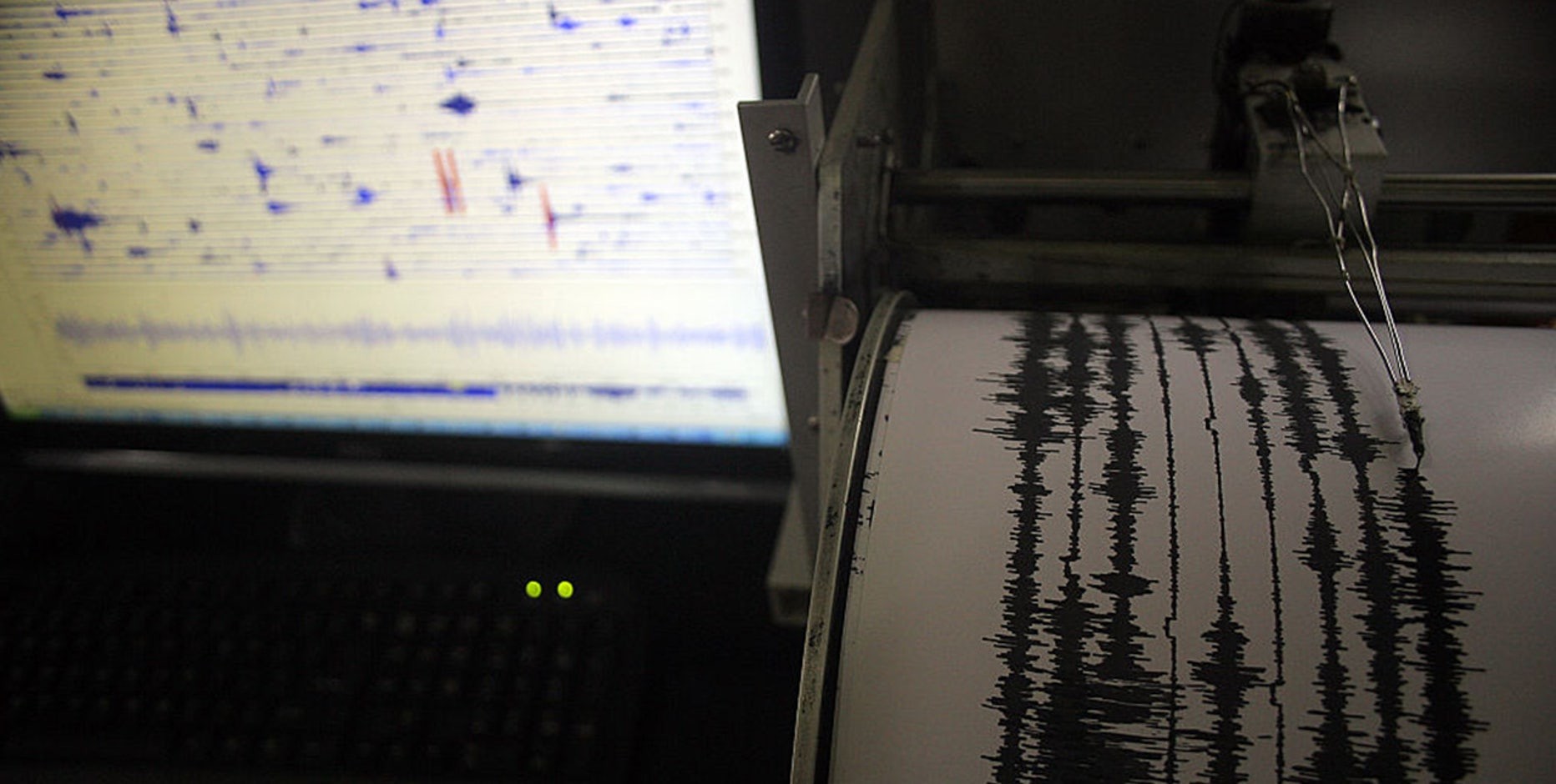
4.1 Seismographs and Seismic Networks
Seismographs are instruments that detect and record ground motion caused by earthquakes. Seismic networks are networks of seismographs that are strategically placed to monitor seismic activity.
4.1.1 How Seismographs Work
Seismographs work by detecting the movement of the ground and converting it into an electrical signal. The signal is then amplified and recorded.
4.1.2 Types of Seismographs
- Vertical Seismographs: Measure vertical ground motion.
- Horizontal Seismographs: Measure horizontal ground motion.
- Broadband Seismographs: Measure a wide range of frequencies.
4.1.3 Seismic Networks
Seismic networks are used to monitor seismic activity around the world. They provide data that is used to locate earthquakes, determine their magnitude, and study the Earth’s interior.
4.2 Early Warning Systems
Early warning systems are designed to detect earthquakes and provide a few seconds or minutes of warning before the shaking arrives.
4.2.1 How Early Warning Systems Work
Early warning systems work by detecting the primary waves (P-waves) of an earthquake, which travel faster than the secondary waves (S-waves) that cause most of the shaking. The system uses the P-waves to estimate the location and magnitude of the earthquake and then sends out an alert to people in the affected area.
4.2.2 Limitations of Early Warning Systems
Early warning systems are not foolproof. They can only provide a limited amount of warning, and they may not be effective for earthquakes that occur very close to the sensor.
4.3 Data Analysis and Modeling
Data analysis and modeling are used to study earthquakes and assess the risk of future earthquakes.
4.3.1 Earthquake Catalogs
Earthquake catalogs are databases that contain information about earthquakes, such as their location, magnitude, and time of occurrence.
4.3.2 Seismic Hazard Maps
Seismic hazard maps show the level of ground shaking that is expected to occur in a given area. These maps are used to inform building codes and land-use planning.
4.3.3 Earthquake Forecasting
Earthquake forecasting is the process of predicting the likelihood of future earthquakes. This is a challenging task, and earthquake forecasts are not always accurate.
4.4 Technological Advancements
Technological advancements are improving our ability to monitor earthquakes and provide early warnings.
4.4.1 Improved Sensors
New sensors are more sensitive and can detect smaller earthquakes.
4.4.2 Faster Data Processing
Faster data processing allows for more rapid analysis of earthquake data.
4.4.3 Enhanced Communication Systems
Enhanced communication systems allow for more rapid dissemination of earthquake warnings.
| Technology | Description | Benefits |
|---|---|---|
| Seismographs | Instruments that detect and record ground motion caused by earthquakes | Provide data for locating earthquakes, determining their magnitude, and studying the Earth’s interior |
| Early Warning Systems | Systems that detect earthquakes and provide a few seconds or minutes of warning before the shaking arrives | Allow people to take protective actions, such as dropping, covering, and holding on |
| Data Analysis | Techniques used to study earthquakes and assess the risk of future earthquakes | Inform building codes, land-use planning, and earthquake forecasting |
| Technological Advancements | Improvements in sensors, data processing, and communication systems | Enhance our ability to monitor earthquakes, provide early warnings, and reduce the risk of earthquake damage and injury |
5. Long-Term Seismic Trends in the Northeastern United States
Understanding long-term seismic trends can help us better prepare for future earthquakes.
5.1 Historical Earthquake Patterns
The northeastern United States has a history of moderate earthquakes. While the region is not as seismically active as California, it has experienced several significant earthquakes over the past few centuries.
5.1.1 Notable Earthquakes
- 1755 Cape Ann Earthquake: This earthquake, which occurred off the coast of Massachusetts, is one of the largest earthquakes ever recorded in the northeastern United States.
- 1884 New York City Earthquake: This earthquake caused significant damage in New York City and the surrounding area.
- 2011 Virginia Earthquake: This earthquake, which was centered in Virginia, was felt throughout the eastern United States.
5.1.2 Recurrence Intervals
The recurrence interval for large earthquakes in the northeastern United States is long, meaning that large earthquakes are relatively rare. However, smaller earthquakes occur more frequently.
5.2 Geological Factors Contributing to Seismic Activity
Several geological factors contribute to seismic activity in the northeastern United States.
5.2.1 Ancient Fault Lines
The region is home to several ancient fault lines, such as the Ramapo Fault. These fault lines are not as active as faults in California, but they can still generate earthquakes.
5.2.2 Glacial Rebound
The Earth’s crust in the northeastern United States is still rebounding from the removal of ice sheets after the last ice age. This process can cause stress changes in the crust, which can trigger earthquakes.
5.3 Impact of Urbanization
Urbanization can impact seismic activity in several ways.
5.3.1 Increased Population Density
Increased population density means that more people are at risk from earthquakes.
5.3.2 Infrastructure Development
Infrastructure development can change the stress on the Earth’s crust, which can trigger earthquakes.
5.3.3 Building Codes
Building codes can help reduce the risk of earthquake damage.
5.4 Climate Change Considerations
Climate change can indirectly influence seismic activity by altering the distribution of mass on the Earth’s surface.
5.4.1 Melting Glaciers
The melting of glaciers can reduce the weight on the Earth’s crust, which can cause the crust to rebound. This process can change the stress on faults and potentially trigger earthquakes.
5.4.2 Sea Level Rise
Sea level rise can increase the load on coastal areas, which can also change the stress on faults. Additionally, sea level rise can lead to erosion and landslides, which can destabilize the ground and increase the risk of earthquakes.
5.5 Future Seismic Risk Assessments
Future seismic risk assessments are needed to better understand the potential for earthquakes in the northeastern United States.
5.5.1 Improved Monitoring
Improved monitoring can help us better understand seismic activity and assess the risk of future earthquakes.
5.5.2 Advanced Modeling
Advanced modeling can help us better understand the complex geological processes that contribute to seismic activity.
5.5.3 Public Education
Public education can help people prepare for earthquakes and reduce the risk of injury and damage.
| Trend | Description | Impact |
|---|---|---|
| Historical Patterns | The northeastern United States has a history of moderate earthquakes. | Provides data for understanding long-term seismic trends |
| Geological Factors | Ancient fault lines and glacial rebound contribute to seismic activity. | Explains why earthquakes occur in the region |
| Urbanization | Increased population density, infrastructure development, and building codes can impact seismic risk. | Highlights the need for earthquake preparedness and mitigation measures |
| Climate Change | Melting glaciers and sea level rise can indirectly influence seismic activity. | Emphasizes the importance of considering climate change in seismic risk assessments |
| Risk Assessments | Improved monitoring, advanced modeling, and public education are needed to assess future seismic risk. | Provides a roadmap for reducing the risk of earthquake damage and injury |
6. Case Studies of Past Earthquakes in the Region
Examining past earthquakes in the region provides valuable insights into potential future events.
6.1 The 1755 Cape Ann Earthquake
The 1755 Cape Ann earthquake is one of the largest earthquakes ever recorded in the northeastern United States.
6.1.1 Details of the Earthquake
- Date: November 18, 1755
- Location: Off the coast of Cape Ann, Massachusetts
- Estimated Magnitude: 5.9-6.2
- Intensity: Estimated to be VIII (Severe) on the Modified Mercalli Intensity Scale
6.1.2 Impact of the Earthquake
The earthquake caused significant damage throughout New England. Buildings were damaged, chimneys collapsed, and the ground cracked. The earthquake was felt as far away as Maryland and Nova Scotia.
6.1.3 Lessons Learned
The 1755 Cape Ann earthquake demonstrated the potential for large earthquakes in the northeastern United States. It highlighted the need for earthquake preparedness and mitigation measures.
6.2 The 1884 New York City Earthquake
The 1884 New York City earthquake caused significant damage in New York City and the surrounding area.
6.2.1 Details of the Earthquake
- Date: August 10, 1884
- Location: New York City
- Estimated Magnitude: 5.2
- Intensity: Estimated to be VII (Very Strong) on the Modified Mercalli Intensity Scale
6.2.2 Impact of the Earthquake
The earthquake caused damage to buildings, cracked plaster, and broke windows. The earthquake was felt throughout the New York City area and as far away as Philadelphia and Boston.
6.2.3 Lessons Learned
The 1884 New York City earthquake demonstrated that even moderate earthquakes can cause significant damage in urban areas. It highlighted the need for building codes that require structures to be designed to withstand earthquake forces.
6.3 The 2011 Virginia Earthquake
The 2011 Virginia earthquake, which was centered in Virginia, was felt throughout the eastern United States.
6.3.1 Details of the Earthquake
- Date: August 23, 2011
- Location: Mineral, Virginia
- Magnitude: 5.8
- Intensity: Estimated to be VII (Very Strong) on the Modified Mercalli Intensity Scale
6.3.2 Impact of the Earthquake
The earthquake caused damage to buildings, including the Washington Monument. The earthquake was felt throughout the eastern United States and as far away as Canada.
6.3.3 Lessons Learned
The 2011 Virginia earthquake demonstrated that earthquakes can be felt over a wide area in the eastern United States. It highlighted the need for earthquake preparedness and mitigation measures throughout the region.
| Earthquake | Date | Location | Magnitude | Impact | Lessons Learned |
|---|---|---|---|---|---|
| 1755 Cape Ann Earthquake | November 18, 1755 | Cape Ann, MA | 5.9-6.2 | Significant damage throughout New England | Demonstrated the potential for large earthquakes in the northeastern United States |
| 1884 New York City Earthquake | August 10, 1884 | New York City | 5.2 | Damage to buildings, cracked plaster, and broke windows | Highlighted the need for building codes that require structures to be designed to withstand earthquake forces |
| 2011 Virginia Earthquake | August 23, 2011 | Mineral, VA | 5.8 | Damage to buildings, including the Washington Monument | Demonstrated that earthquakes can be felt over a wide area in the eastern United States |
7. Community Initiatives and Government Policies for Earthquake Safety
Effective community initiatives and government policies are essential for enhancing earthquake safety.
7.1 Building Codes and Regulations
Building codes and regulations are designed to ensure that structures are built to withstand earthquake forces.
7.1.1 International Building Code (IBC)
The International Building Code (IBC) is a model building code that is used in many parts of the United States. The IBC includes provisions for earthquake-resistant design.
7.1.2 State and Local Building Codes
State and local building codes may have additional requirements for earthquake-resistant design.
7.1.3 Enforcement of Building Codes
Effective enforcement of building codes is essential to ensure that structures are built to withstand earthquake forces.
7.2 Public Awareness Campaigns
Public awareness campaigns can help educate people about earthquake hazards and how to prepare for them.
7.2.1 Earthquake Preparedness Workshops
Earthquake preparedness workshops can provide people with information and training on how to prepare for earthquakes.
7.2.2 Educational Materials
Educational materials, such as brochures and websites, can provide people with information about earthquake hazards and how to prepare for them.
7.2.3 Social Media Campaigns
Social media campaigns can be used to reach a wide audience and promote earthquake preparedness.
7.3 Emergency Response Planning
Emergency response planning is essential to ensure that communities are prepared to respond to earthquakes.
7.3.1 Community Emergency Response Teams (CERT)
Community Emergency Response Teams (CERT) are teams of volunteers who are trained to assist in emergency situations.
7.3.2 Evacuation Plans
Evacuation plans can help people evacuate safely in the event of an earthquake.
7.3.3 Communication Systems
Communication systems are essential for coordinating emergency response efforts.
7.4 Funding for Earthquake Research and Mitigation
Funding for earthquake research and mitigation is essential to improve our understanding of earthquake hazards and develop effective mitigation measures.
7.4.1 Government Funding
Government funding can support earthquake research, monitoring, and mitigation efforts.
7.4.2 Private Funding
Private funding can also support earthquake research and mitigation efforts.
| Initiative/Policy | Description | Benefits |
|---|
