Thunderstorms happen due to a combination of moisture, unstable air, and a lifting mechanism, creating the dramatic displays of lightning and thunder we observe; WHY.EDU.VN offers a comprehensive guide to understanding these weather phenomena. Unstable air rises, cools, and condenses, forming clouds and eventually leading to precipitation and electrical activity, crucial for generating thunderstorms. Explore cloud formation and atmospheric conditions to broaden your understanding.
1. What Are the Key Ingredients for a Thunderstorm?
The key ingredients for a thunderstorm are moisture, unstable air, and a lifting mechanism. These elements work together to create the atmospheric conditions necessary for thunderstorms to form and intensify. Moisture provides the water vapor needed for cloud formation and precipitation. Unstable air, which is warmer and less dense than its surroundings, rises rapidly, fueling the storm’s growth. A lifting mechanism, such as fronts, terrain, or surface heating, initiates the upward motion of the air.
1.1. How Does Moisture Contribute to Thunderstorm Formation?
Moisture is essential for thunderstorm formation because it provides the water vapor needed to form clouds and precipitation. According to the National Weather Service, thunderstorms require an ample supply of moisture in the lower and middle levels of the atmosphere. This moisture typically comes from sources such as warm bodies of water, like the Gulf of Mexico or the Atlantic Ocean. When warm, moist air rises, it cools and condenses, forming clouds. The condensation process releases latent heat, which further warms the air and makes it more buoyant, leading to the development of thunderstorms.
1.2. What is Unstable Air and Why is it Important?
Unstable air is crucial for thunderstorm development because it allows air parcels to rise rapidly and continuously. According to a study by the University Corporation for Atmospheric Research (UCAR), unstable air occurs when a layer of warm, less dense air is located beneath a layer of cooler, more dense air. In this situation, if a parcel of warm air is lifted, it will continue to rise because it is lighter than its surroundings. This rising motion, known as convection, is a key driver of thunderstorm formation. The greater the instability, the more intense the thunderstorm is likely to be.
1.3. What are the Common Lifting Mechanisms?
Common lifting mechanisms include fronts, terrain, and surface heating. These mechanisms initiate the upward motion of air needed to start thunderstorm development. Fronts, such as cold fronts or warm fronts, can force air to rise as they move through an area. Terrain, like mountains, can cause air to rise as it flows over them, a process known as orographic lifting. Surface heating occurs when the sun warms the ground, causing the air near the surface to become warmer and rise. According to the National Weather Service, these lifting mechanisms often work in combination to create conditions favorable for thunderstorm formation.
2. How Does Convection Play a Role in Thunderstorms?
Convection plays a vital role in thunderstorms by transporting warm, moist air upwards, leading to cloud formation and precipitation. Convection is the process of heat transfer through the movement of fluids (air or water). In the context of thunderstorms, it involves warm air rising from the surface of the Earth into the atmosphere. As this warm air rises, it cools and condenses, forming clouds. The release of latent heat during condensation further fuels the convective process, leading to the development of cumulonimbus clouds, which are the hallmark of thunderstorms.
2.1. What is Convection?
Convection is the process of heat transfer through the movement of fluids (air or water). According to the American Meteorological Society, convection occurs when there is a temperature difference within a fluid, causing warmer, less dense fluid to rise and cooler, more dense fluid to sink. This process results in the transfer of heat from one location to another. In the atmosphere, convection is a primary mechanism for vertical heat transport, playing a critical role in weather phenomena such as thunderstorms.
2.2. How Does Surface Heating Initiate Convection?
Surface heating initiates convection by warming the air near the ground, causing it to become less dense and rise. The sun’s energy heats the Earth’s surface, which in turn warms the air directly above it. According to the National Weather Service, this process is most effective on clear, sunny days when there is strong solar radiation. As the air near the surface warms, it becomes buoyant and begins to rise, initiating convective currents. These currents transport heat and moisture upwards, leading to the formation of clouds and potentially thunderstorms if other necessary conditions are present.
2.3. What Happens as the Air Rises?
As the air rises, it cools and condenses, forming clouds and releasing latent heat. According to the National Oceanic and Atmospheric Administration (NOAA), as air rises in the atmosphere, it expands due to decreasing air pressure. This expansion causes the air to cool. If the rising air is sufficiently moist, the water vapor within it will condense into liquid water droplets or ice crystals, forming clouds. The condensation process releases latent heat, which warms the surrounding air and makes it more buoyant, further fueling the upward motion.
 convection process in thunderstorm development
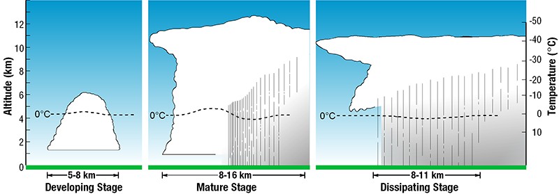
3. What Are the Different Stages of a Thunderstorm?
Thunderstorms have three main stages: the developing stage, the mature stage, and the dissipating stage. Each stage is characterized by specific atmospheric conditions and processes. Understanding these stages can help in predicting the intensity and duration of thunderstorms.
3.1. What Occurs During the Developing Stage?
During the developing stage, a cumulus cloud is pushed upward by a rising column of air (updraft). The cumulus cloud soon looks like a tower (called towering cumulus) as the updraft continues to develop. According to the National Weather Service, there is little to no rain during this stage, but occasional lightning may occur. The primary process during this stage is the continuous uplift of warm, moist air, which leads to the growth of the cloud.
3.2. What Defines the Mature Stage of a Thunderstorm?
The thunderstorm enters the mature stage when the updraft continues to feed the storm, but precipitation begins to fall out of the storm, creating a downdraft (a column of air pushing downward). When the downdraft and rain-cooled air spreads out along the ground, it forms a gust front, or a line of gusty winds. The National Severe Storms Laboratory notes that the mature stage is the most likely time for hail, heavy rain, frequent lightning, strong winds, and tornadoes.
3.3. What Happens During the Dissipating Stage?
Eventually, a large amount of precipitation is produced, and the updraft is overcome by the downdraft, beginning the dissipating stage. At the ground, the gust front moves out a long distance from the storm and cuts off the warm moist air that was feeding the thunderstorm. Rainfall decreases in intensity, but lightning remains a danger. According to the National Weather Service, the storm weakens and eventually dissipates as the supply of warm, moist air is cut off.
4. What is the Role of Ice Particles and Electrical Charge in Thunderstorms?
Ice particles and electrical charge play a critical role in the development of lightning within thunderstorms. The collision of ice particles in the upper reaches of the storm leads to the separation of electrical charges, which eventually results in lightning strikes. This process is fundamental to understanding the electrical nature of thunderstorms.
4.1. How are Ice Particles Created in a Thunderstorm?
As a storm rises into freezing air, different types of ice particles can be created from freezing liquid drops. The ice particles can grow by condensing vapor (like frost) and by collecting smaller liquid drops that haven’t frozen yet (a state called “supercooled”). According to a study by the American Meteorological Society, the presence of ice particles is essential for the electrification process in thunderstorms.
4.2. How Does Electrical Charge Build Up?
When two ice particles collide, they usually bounce off each other, but one particle can rip off a little bit of ice from the other one and grab some electric charge. Lots of these collisions build up big regions of electric charges, according to the National Severe Storms Laboratory. The exact mechanism of charge separation is still a topic of research, but it is believed that the transfer of charge is related to the size and temperature of the ice particles.
4.3. What Causes Lightning?
The buildup of electrical charges causes lightning. When the electrical potential between the positive and negative charge regions becomes strong enough, a rapid discharge of electricity occurs, creating a bolt of lightning. The National Weather Service explains that lightning can occur within a cloud, between clouds, or between a cloud and the ground. The rapid heating of the air around the lightning channel causes it to expand violently, creating the sound waves we hear as thunder.
5. What Does a Thunderstorm Look Like?
Thunderstorms can look like tall heads of cauliflower or they can have “anvils.” An anvil is the flat cloud formation at the top of the storm. An anvil forms when the updraft (warm air rising) has reached a point where the surrounding air is about the same temperature or even warmer. The cloud growth abruptly stops and flattens out to take the shape of an anvil. Observing the visual characteristics of thunderstorms can provide clues about their intensity and potential hazards.
5.1. What is an Anvil Cloud?
An anvil cloud is the flat cloud formation at the top of a thunderstorm. According to the National Weather Service, an anvil forms when the updraft (warm air rising) has reached a point where the surrounding air is about the same temperature or even warmer. The cloud growth abruptly stops and flattens out to take the shape of an anvil. The presence of an anvil cloud often indicates a mature thunderstorm with strong updrafts.
5.2. What do Cauliflower-Shaped Thunderstorms Indicate?
Cauliflower-shaped thunderstorms indicate strong updrafts and active convection. These clouds have a puffy, rounded appearance that resembles the head of a cauliflower. According to the American Meteorological Society, this shape is indicative of rapidly rising air currents that are carrying moisture and heat upwards. These types of thunderstorms are often associated with severe weather, including heavy rain, hail, and strong winds.
5.3. How Can Visual Cues Help Predict Thunderstorm Severity?
Visual cues can help predict thunderstorm severity by providing information about the storm’s structure and intensity. For example, a towering cumulonimbus cloud with a dark, ominous base may indicate a severe thunderstorm with the potential for strong winds, hail, and tornadoes. The presence of an anvil cloud can also be a sign of a mature, well-developed thunderstorm. According to the National Weather Service, trained storm spotters use these visual cues, along with radar data, to assess the severity of thunderstorms and issue warnings to the public.
6. What Kinds of Damage Can Thunderstorms Cause?
Many hazardous weather events are associated with thunderstorms. Under the right conditions, rainfall from thunderstorms causes flash flooding, killing more people each year than hurricanes, tornadoes, or lightning. Lightning is responsible for many fires around the world each year, and causes fatalities. Hail up to the size of softballs damages cars and windows, and kills livestock caught out in the open. Strong (up to more than 120 mph) straight-line winds associated with thunderstorms knock down trees, power lines, and mobile homes. Tornadoes (with winds up to about 300 mph) can destroy all but the best-built man-made structures.
6.1. How Does Rainfall Cause Flash Flooding?
Rainfall causes flash flooding when the ground cannot absorb water quickly enough, leading to rapid runoff and rising water levels. According to the National Weather Service, flash floods are particularly dangerous because they can occur suddenly and without warning. Heavy rainfall from thunderstorms can overwhelm drainage systems and cause rivers, streams, and urban areas to flood rapidly. Factors such as soil saturation, topography, and the intensity and duration of the rainfall can all contribute to the risk of flash flooding.
6.2. What is the Impact of Lightning Strikes?
Lightning strikes can cause fires, fatalities, and damage to property. Lightning is one of the leading causes of weather-related deaths and injuries in the United States. According to the National Oceanic and Atmospheric Administration (NOAA), lightning can ignite fires in forests, grasslands, and buildings, leading to significant damage and economic losses. Lightning strikes can also cause power outages and damage to electronic equipment. People who are struck by lightning can suffer severe burns, cardiac arrest, and neurological damage.
6.3. How Does Hail Damage Property and Agriculture?
Hail damages property and agriculture by impacting surfaces with considerable force. Hailstones, which are balls of ice that form in thunderstorms, can range in size from small pebbles to larger than softballs. According to the National Weather Service, large hailstones can break windows, dent cars, and damage roofs. Hail can also cause significant damage to crops, destroying fields of corn, soybeans, and other agricultural products. The economic impact of hail damage can be substantial, particularly in agricultural regions.
7. Where are Severe Thunderstorms Most Common?
The greatest severe weather threat in the U.S. extends from Texas to southern Minnesota. But, no place in the United States is completely safe from the threat of severe weather. Understanding the geographic distribution of severe thunderstorms can help individuals and communities prepare for and mitigate the risks associated with these events.
7.1. Why is the Central U.S. Prone to Severe Thunderstorms?
The central U.S. is prone to severe thunderstorms due to its unique geographic location and atmospheric conditions. This region, often referred to as “Tornado Alley,” is where warm, moist air from the Gulf of Mexico collides with cold, dry air from Canada and the Rocky Mountains. According to the National Severe Storms Laboratory, this collision creates a highly unstable atmosphere that is conducive to the formation of severe thunderstorms. The presence of a strong jet stream aloft further enhances the development of these storms.
7.2. Are Coastal Regions at Risk?
Coastal regions are also at risk from severe thunderstorms, although the specific hazards may differ from those in the central U.S. According to the National Weather Service, coastal thunderstorms can produce strong winds, heavy rain, and frequent lightning. Coastal areas are also vulnerable to waterspouts, which are tornadoes that form over water. The combination of thunderstorms and coastal flooding can create particularly dangerous conditions.
7.3. How Does Terrain Influence Thunderstorm Patterns?
Terrain influences thunderstorm patterns by affecting the flow of air and the development of convective currents. Mountains can force air to rise, leading to orographic lifting and the formation of thunderstorms. According to the American Meteorological Society, the leeward side of mountains (the side sheltered from the wind) can experience enhanced thunderstorm activity due to the convergence of air currents. Coastal areas can also experience sea breeze thunderstorms, which form when cool air from the ocean moves inland and interacts with warmer air over the land.
8. What is the Difference Between a Severe Thunderstorm Watch and a Severe Thunderstorm Warning?
A Severe Thunderstorm WATCH is issued by the NOAA Storm Prediction Center meteorologists who are watching the weather 24/7 across the entire U.S. for weather conditions that are favorable for severe thunderstorms. A watch can cover parts of a state or several states. Watch and prepare for severe weather and stay tuned to NOAA Weather Radio to know when warnings are issued. A Severe Thunderstorm WARNING is issued by your local NOAA National Weather Service Forecast Office meteorologists who watch a designated area 24/7 for severe weather that has been reported by spotters or indicated by radar. Warnings mean there is a serious threat to life and property to those in the path of the storm. ACT now to find safe shelter! A warning can cover parts of counties or several counties in the path of danger.
8.1. What Does a Severe Thunderstorm Watch Mean?
A severe thunderstorm watch means that conditions are favorable for the development of severe thunderstorms in the specified area. According to the NOAA Storm Prediction Center, a watch is issued when there is a significant risk of severe thunderstorms, but the storms have not yet developed. During a watch, it is important to stay informed and be prepared to take action if a warning is issued.
8.2. What Actions Should You Take During a Watch?
During a severe thunderstorm watch, you should stay informed by monitoring weather updates from reliable sources such as NOAA Weather Radio, local news media, and the National Weather Service website. The Federal Emergency Management Agency (FEMA) recommends that you review your emergency plan, gather supplies, and be prepared to seek shelter if a warning is issued. It is also a good idea to secure outdoor objects that could be blown away by strong winds.
8.3. What Does a Severe Thunderstorm Warning Imply?
A severe thunderstorm warning means that a severe thunderstorm has been detected and is posing an imminent threat to life and property. According to the National Weather Service, a warning is issued when a severe thunderstorm has been reported by trained spotters or indicated by radar. During a warning, it is crucial to take immediate action to protect yourself and others.
9. How to Stay Safe During a Thunderstorm?
Staying safe during a thunderstorm involves seeking shelter, avoiding potential hazards, and staying informed about weather conditions. Thunderstorms can produce a variety of dangerous conditions, including lightning, strong winds, hail, and flash flooding. Taking appropriate safety measures can significantly reduce the risk of injury or death.
9.1. Where is the Safest Place to Take Shelter?
The safest place to take shelter during a thunderstorm is inside a sturdy building or a hard-topped vehicle. According to the National Weather Service, buildings provide the best protection from lightning and strong winds. If you are caught outdoors, avoid open fields, hilltops, and bodies of water. If possible, find shelter in a low-lying area such as a ravine or ditch.
9.2. What Should You Avoid During a Thunderstorm?
During a thunderstorm, you should avoid contact with electrical appliances, plumbing fixtures, and metal objects. According to the Centers for Disease Control and Prevention (CDC), lightning can travel through electrical wires and plumbing, so it is important to avoid using electronic devices, taking showers, or washing dishes during a thunderstorm. Metal objects, such as fences and poles, can also conduct electricity and should be avoided.
9.3. How Can You Stay Informed About Thunderstorm Activity?
You can stay informed about thunderstorm activity by monitoring weather updates from reliable sources such as NOAA Weather Radio, local news media, and the National Weather Service website. Many weather apps and websites provide real-time information about thunderstorm locations, intensity, and warnings. According to the National Weather Service, it is important to have multiple sources of information so that you can stay informed even if one source fails.
10. FAQ About Thunderstorms
Here are some frequently asked questions about thunderstorms, providing quick answers to common queries. This section aims to address typical curiosities and concerns about these weather phenomena.
10.1. Can Thunderstorms Occur in Winter?
Yes, thunderstorms can occur in winter, although they are less common than in the spring and summer months. These are often referred to as thundersnow, where thunder and lightning occur during a snowstorm.
10.2. How Far Away Can You Hear Thunder?
You can typically hear thunder up to 25 miles away from the lightning strike. The distance depends on atmospheric conditions and the presence of obstructions.
10.3. Is it Safe to Use a Cell Phone During a Thunderstorm?
It is generally safe to use a cell phone during a thunderstorm, as long as you are indoors and not connected to a landline. The primary risk is from lightning striking the building you are in, not the cell phone itself.
10.4. What Should You Do if Caught in a Thunderstorm While Swimming?
If caught in a thunderstorm while swimming, immediately exit the water and seek shelter in a safe location, such as a sturdy building or a hard-topped vehicle.
10.5. How Can You Tell if a Thunderstorm is Approaching?
You can tell if a thunderstorm is approaching by observing dark, towering clouds, increasing wind speeds, and frequent lightning. Listening for thunder can also indicate an approaching storm.
10.6. Are All Thunderstorms Dangerous?
Not all thunderstorms are dangerous, but all thunderstorms produce lightning, which can be hazardous. Severe thunderstorms, which produce large hail, strong winds, and tornadoes, pose the greatest threat.
10.7. How Long Do Thunderstorms Typically Last?
Thunderstorms typically last from 30 minutes to several hours. The duration depends on the atmospheric conditions and the storm’s intensity.
10.8. Can Thunderstorms Form at Night?
Yes, thunderstorms can form at night. They often occur in the late afternoon and evening hours due to daytime heating, but they can also develop at any time of day or night.
10.9. What is a Supercell Thunderstorm?
A supercell thunderstorm is a severe thunderstorm characterized by a rotating updraft called a mesocyclone. These storms are the most dangerous and can produce tornadoes, large hail, and strong winds.
10.10. How Does Climate Change Affect Thunderstorms?
Climate change is expected to affect thunderstorms by altering atmospheric conditions. Some studies suggest that a warmer climate could lead to an increase in the frequency and intensity of severe thunderstorms in certain regions.
Understanding the science behind thunderstorms can help you stay safe and informed during these weather events. For more in-depth answers and expert insights, visit WHY.EDU.VN.
Are you still curious about thunderstorms and other weather phenomena? Do you find it challenging to get reliable and comprehensive answers to your questions? At WHY.EDU.VN, we understand the importance of having access to accurate and trustworthy information. Our platform connects you with experts who can provide detailed explanations and insights into a wide range of topics. Don’t let your questions go unanswered. Visit why.edu.vn today at 101 Curiosity Lane, Answer Town, CA 90210, United States, or reach out to us via Whatsapp at +1 (213) 555-0101. Let us help you explore the world around you and satisfy your curiosity.