Why Are Clouds Flat On The Bottom? You’ve likely noticed that cumulus clouds often exhibit a flat base. WHY.EDU.VN explains this fascinating phenomenon stemming from the condensation process at a specific altitude known as the lifting condensation level. Understand cloud formation, atmospheric layers, and the science behind these beautiful formations.
1. Understanding Cloud Formation and Flat Bases
Clouds are a mesmerizing and integral part of our atmosphere, each with unique characteristics. One of the most commonly observed features is the flat bottom seen in many cumulus clouds. But why do clouds have flat bottoms? The answer lies in the way these clouds form and the atmospheric conditions that govern their development.
1.1. The Process of Cloud Formation
Cloud formation begins with the sun’s energy heating the Earth’s surface. This warmth, in turn, heats the air directly above it. Warm air is less dense than cool air, causing it to rise. This rising air is known as a thermal. As the warm air ascends, it expands and cools. The rate at which it cools is known as the adiabatic lapse rate.
As the air rises and cools, the water vapor within it starts to condense. Water vapor is simply water in its gaseous form, invisible to the naked eye. As the air reaches a certain altitude, it cools to its dew point temperature. The dew point is the temperature at which the air becomes saturated with water vapor, and condensation begins.
When the air reaches its dew point, the water vapor condenses around tiny particles in the air, such as dust, pollen, or salt. These particles act as condensation nuclei, providing a surface for the water vapor to latch onto. As more water vapor condenses, tiny water droplets form. These droplets are so small that they remain suspended in the air.
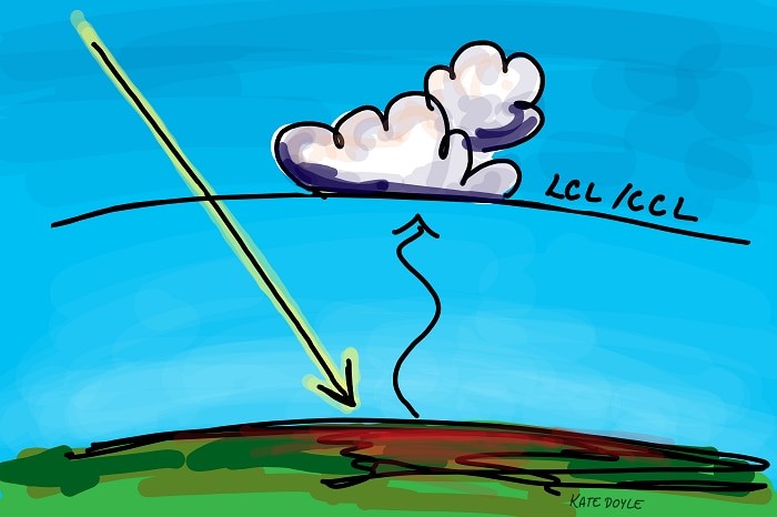
1.2. The Lifting Condensation Level (LCL)
The lifting condensation level (LCL) is the altitude at which the rising air reaches its dew point temperature, and condensation begins. This is a crucial factor in understanding why clouds have flat bottoms. The LCL marks the base of the cloud.
Below the LCL, the air is unsaturated, meaning it can hold more water vapor. As the air rises, it cools, but condensation does not occur until the LCL is reached. Once the air reaches the LCL, condensation begins, and the cloud starts to form. Since the air at this level is at the same temperature (the dew point), condensation occurs uniformly, resulting in a flat cloud base.
1.3. Factors Influencing the LCL
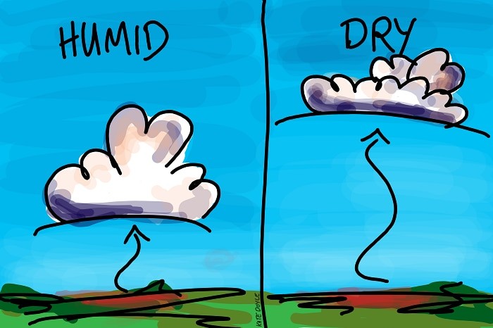
Several factors determine the height of the LCL, primarily temperature and humidity.
- Humidity: Humidity is the amount of water vapor in the air. When the humidity is high, the air contains more water vapor, so it doesn’t need to rise as high to reach its dew point. This results in a lower LCL and lower cloud bases.
- Temperature: Temperature also plays a significant role. Warmer air can hold more moisture than cooler air. Therefore, if the temperature is high, the air needs to rise higher to cool down to its dew point, resulting in a higher LCL.
Meteorologists use these factors to predict the height of cloud bases. By knowing the temperature and humidity of the air near the ground, they can calculate the LCL and forecast where clouds will form.
Table: Factors Influencing Lifting Condensation Level (LCL)
| Factor | Influence on LCL | Explanation |
|---|---|---|
| Humidity | Higher humidity | Air reaches dew point at lower altitudes, resulting in a lower LCL and lower cloud bases. |
| Lower humidity | Air needs to rise higher to reach dew point, leading to a higher LCL and higher cloud bases. | |
| Temperature | Higher temperature | Air needs to rise higher to cool down to dew point, resulting in a higher LCL. |
| Lower temperature | Air reaches dew point at lower altitudes, resulting in a lower LCL. |
1.4. Visualizing the Process
Imagine a sunny day with warm air rising from the ground. As the air ascends, it cools, and the water vapor within it gets closer to its saturation point. At a certain altitude, the air reaches its dew point, and condensation begins. This altitude marks the flat base of the clouds. Above this level, the cloud continues to grow as more warm, moist air rises and condenses.
The flat base is a visual representation of the level at which condensation consistently occurs, creating the distinct cloud shape we often observe.
2. Cumulus Clouds: The Typical Examples
Cumulus clouds are the quintessential example of clouds with flat bottoms. These clouds are puffy, white, and often described as looking like cotton balls. They are commonly seen on sunny days and are formed by rising thermals of warm, moist air.
2.1. Formation of Cumulus Clouds
Cumulus clouds form through convection. The sun heats the ground, which warms the air above it. This warm air rises, expands, and cools. As it reaches the LCL, water vapor condenses, forming the cloud. The continued rise of warm air fuels the growth of the cloud, leading to its characteristic puffy shape.
2.2. Characteristics of Cumulus Clouds
Cumulus clouds have several distinct characteristics:
- Flat Base: As discussed, the flat base is due to condensation occurring at the LCL.
- Puffy Top: The puffy top is a result of the continued rising of warm air and condensation of water vapor.
- White Color: The white color is due to the reflection of sunlight by the tiny water droplets in the cloud.
- Distinct Boundaries: Cumulus clouds often have well-defined edges, making them easily recognizable.
2.3. Cumulus Cloud Types
There are several types of cumulus clouds, each with slightly different characteristics:
- Cumulus Humilis: These are small, fair-weather cumulus clouds with little vertical development.
- Cumulus Mediocris: These are medium-sized cumulus clouds with moderate vertical development.
- Cumulus Congestus: These are large, towering cumulus clouds that can develop into thunderstorms.
Each type of cumulus cloud shares the characteristic flat base, but their vertical development and potential for precipitation vary.
Table: Types of Cumulus Clouds
| Cloud Type | Size | Vertical Development | Weather Implications |
|---|---|---|---|
| Cumulus Humilis | Small | Little | Fair weather |
| Cumulus Mediocris | Medium | Moderate | Possible light showers |
| Cumulus Congestus | Large | Towering | Potential for thunderstorms |
2.4. Cumulus Clouds and Weather
Cumulus clouds are often associated with fair weather. Cumulus humilis clouds, in particular, are a sign of stable atmospheric conditions. However, cumulus clouds can also indicate the potential for more significant weather events. Cumulus congestus clouds, for example, can grow into cumulonimbus clouds, which are associated with thunderstorms.
The presence and type of cumulus clouds can provide valuable information about the current and future weather conditions.
3. The Science Behind Cloud Base Formation
To further understand why clouds are flat on the bottom, it’s essential to delve into the scientific principles that govern cloud formation.
3.1. Thermodynamics of Air
Thermodynamics plays a crucial role in cloud formation. As warm air rises, it expands and cools. This cooling is due to the decrease in atmospheric pressure with altitude. The rate at which the air cools is known as the adiabatic lapse rate.
There are two types of adiabatic lapse rates:
- Dry Adiabatic Lapse Rate: This is the rate at which dry air cools as it rises. It is approximately 9.8 degrees Celsius per kilometer.
- Moist Adiabatic Lapse Rate: This is the rate at which saturated air cools as it rises. It is lower than the dry adiabatic lapse rate, typically around 5-6 degrees Celsius per kilometer, because condensation releases latent heat, which slows down the cooling process.
The difference in these lapse rates affects the stability of the atmosphere and the development of clouds.
3.2. Atmospheric Stability
Atmospheric stability refers to the tendency of air to either rise or sink. If the air is stable, it will resist vertical movement. If the air is unstable, it will continue to rise if given a nudge.
The stability of the atmosphere is determined by comparing the temperature of a rising air parcel to the temperature of the surrounding air. If the rising air is warmer than its surroundings, it will continue to rise, and the atmosphere is unstable. If the rising air is cooler than its surroundings, it will sink back down, and the atmosphere is stable.
3.3. Inversions and Cloud Formation
An inversion is a layer in the atmosphere where the temperature increases with altitude. Inversions can prevent the formation of clouds by capping the rising air. If warm air rises into an inversion layer, it will encounter warmer air and stop rising. This can limit the vertical development of clouds and result in flat-topped clouds, as seen in cumulonimbus clouds when they reach the tropopause.
3.4. Role of Condensation Nuclei
Condensation nuclei are tiny particles in the air that provide a surface for water vapor to condense upon. These particles can be dust, pollen, salt, or other aerosols. Without condensation nuclei, water vapor would have a difficult time condensing into cloud droplets.
The availability and type of condensation nuclei can affect the size and number of cloud droplets. In areas with abundant condensation nuclei, clouds tend to have more but smaller droplets. This can affect the cloud’s reflectivity and precipitation potential.
4. Beyond Flat Bottoms: Cloud Tops and Atmospheric Layers
While flat cloud bottoms are a common observation, clouds can also have flat tops. This phenomenon is related to the structure of the atmosphere and the presence of stable layers.
4.1. The Tropopause and Flat Cloud Tops
The tropopause is the boundary between the troposphere and the stratosphere. The troposphere is the lowest layer of the atmosphere, where most of our weather occurs. The stratosphere is the layer above the troposphere, characterized by stable air and increasing temperature with altitude.
When a cumulonimbus cloud grows tall enough to reach the tropopause, it encounters a stable layer of air that prevents it from rising further. This causes the cloud to spread out horizontally, resulting in a flat top. The flat top of a cumulonimbus cloud is often referred to as an anvil cloud due to its shape.
4.2. Atmospheric Layers and Cloud Development
The structure of the atmosphere plays a crucial role in cloud development. The troposphere, stratosphere, mesosphere, and thermosphere each have unique temperature profiles that affect the behavior of air masses and the formation of clouds.
- Troposphere: This is where most clouds form due to the unstable air and decreasing temperature with altitude.
- Stratosphere: This layer is stable and inhibits vertical cloud development.
- Mesosphere: This layer is characterized by decreasing temperature with altitude, but it is too high for most cloud formation.
- Thermosphere: This is the outermost layer of the atmosphere, characterized by increasing temperature with altitude.
Table: Atmospheric Layers and Their Influence on Cloud Formation
| Layer | Altitude (km) | Temperature Profile | Influence on Cloud Formation |
|---|---|---|---|
| Troposphere | 0-10 | Decreasing | Most cloud formation occurs here due to unstable air and decreasing temperature. |
| Stratosphere | 10-50 | Increasing | Stable air inhibits vertical cloud development. |
| Mesosphere | 50-85 | Decreasing | Too high for most cloud formation. |
| Thermosphere | 85+ | Increasing | Outermost layer; minimal influence on cloud formation. |
4.3. Other Factors Affecting Cloud Shape
In addition to the LCL and tropopause, other factors can influence the shape of clouds. Wind shear, for example, can cause clouds to tilt or stretch. Wind shear is the change in wind speed or direction with altitude. It can affect the distribution of water vapor and the stability of the air, leading to unique cloud formations.
5. Real-World Applications and Observations
Understanding cloud formation and the factors that influence cloud shape has practical applications in weather forecasting and climate modeling.
5.1. Weather Forecasting
Meteorologists use their knowledge of cloud formation to predict weather patterns. By observing the types of clouds present and their characteristics, they can infer information about the temperature, humidity, and stability of the atmosphere. This information is used to forecast future weather conditions, including the likelihood of precipitation.
For example, the presence of cumulus clouds with flat bottoms may indicate fair weather, while the presence of towering cumulonimbus clouds may indicate the potential for thunderstorms.
5.2. Climate Modeling
Clouds play a crucial role in the Earth’s climate system. They reflect sunlight back into space, which cools the planet. They also trap heat, which warms the planet. The balance between these two effects is complex and depends on the type, altitude, and coverage of clouds.
Climate models use mathematical equations to simulate the behavior of the atmosphere and oceans. These models include representations of cloud formation and their effects on the Earth’s energy balance. By improving our understanding of cloud processes, we can improve the accuracy of climate models and better predict future climate change.
5.3. Aviation and Cloud Heights
Pilots rely on accurate information about cloud heights for safe navigation. The height of the LCL, or cloud base, is particularly important. Pilots need to know the height of the cloud base to avoid flying into clouds, which can reduce visibility and increase the risk of turbulence or icing.
Aviation weather reports include information about cloud heights, allowing pilots to make informed decisions about flight planning and execution.
6. Why.EDU.VN: Your Source for Understanding Atmospheric Phenomena
At WHY.EDU.VN, we are dedicated to providing clear, accurate, and comprehensive explanations of complex scientific phenomena. Our team of experts is passionate about sharing their knowledge and helping you understand the world around you. Whether you’re curious about cloud formation, atmospheric science, or any other scientific topic, WHY.EDU.VN is your go-to resource.
We understand that finding reliable information can be challenging. That’s why we strive to provide content that is not only informative but also trustworthy and accessible. Our articles are thoroughly researched and reviewed to ensure accuracy and clarity.
6.1. Explore More Questions with WHY.EDU.VN
Have more questions about clouds, weather, or other scientific topics? Visit WHY.EDU.VN to explore our extensive collection of articles, FAQs, and expert insights. We’re here to help you satisfy your curiosity and expand your understanding of the world.
6.2. Engage with Our Community
Join the WHY.EDU.VN community to ask questions, share your knowledge, and connect with other curious minds. Our platform provides a space for thoughtful discussion and collaborative learning. Whether you’re a student, a professional, or simply someone who loves to learn, you’ll find a welcoming and supportive community at WHY.EDU.VN.
7. Debunking Common Misconceptions
There are several common misconceptions about cloud formation and the reasons behind their shapes. Let’s debunk some of these myths:
7.1. Myth: Clouds Are Made of Smoke
One common misconception is that clouds are made of smoke or some other visible substance. In reality, clouds are made of tiny water droplets or ice crystals suspended in the air. These droplets or crystals are so small that they remain aloft due to air currents.
7.2. Myth: All Clouds Have Flat Bottoms
While many clouds, particularly cumulus clouds, exhibit flat bottoms, not all clouds do. Stratus clouds, for example, are layered clouds that can cover the entire sky and may not have a distinct flat base. Cirrus clouds, which are high-altitude, wispy clouds, also lack a well-defined flat bottom.
7.3. Myth: Cloud Shape Is Random
Another misconception is that cloud shape is random. While there is certainly variability in cloud shapes, their formation is governed by specific atmospheric processes and conditions. The flat bottoms of cumulus clouds, for example, are a direct result of condensation occurring at a uniform altitude, the LCL.
7.4. Myth: Clouds Are Weightless
Despite their fluffy appearance, clouds can weigh millions of pounds. The weight of a cloud is due to the combined mass of the water droplets or ice crystals that make it up. However, these droplets are so small and dispersed that they remain suspended in the air.
Table: Debunking Cloud Myths
| Myth | Reality |
|---|---|
| Clouds are made of smoke | Clouds are made of tiny water droplets or ice crystals. |
| All clouds have flat bottoms | Only certain types of clouds, like cumulus, typically have flat bottoms. |
| Cloud shape is random | Cloud shape is influenced by atmospheric processes and conditions. |
| Clouds are weightless | Clouds can weigh millions of pounds due to the combined mass of water droplets or ice crystals, but they remain suspended in the air. |
8. Cloud Observation Tips and Techniques
Observing clouds can be a fascinating and educational activity. Here are some tips and techniques for cloud observation:
8.1. Use a Cloud Identification Guide
A cloud identification guide can help you identify different types of clouds and understand their characteristics. These guides typically include photographs and descriptions of various cloud types, as well as information about their formation and weather implications.
8.2. Observe Cloud Base Heights
Pay attention to the height of cloud bases. Are they low, medium, or high? Low cloud bases typically indicate moist air near the surface, while high cloud bases may indicate drier air.
8.3. Note Cloud Movement and Development
Observe how clouds move and develop over time. Are they growing, shrinking, or staying the same? Are they changing shape? The movement and development of clouds can provide clues about the stability of the atmosphere and potential weather changes.
8.4. Use Online Resources
There are many online resources available for cloud observation and weather information. Websites like the National Weather Service and the World Meteorological Organization provide real-time weather data and forecasts, as well as educational materials about clouds and atmospheric science.
9. Understanding the Impact of Climate Change on Cloud Formation
Climate change is influencing various aspects of our planet, and cloud formation is no exception. Rising global temperatures, altered humidity levels, and changes in atmospheric stability are all impacting how clouds form and behave.
9.1. Impact on Cloud Altitude
Changes in temperature and humidity can affect the lifting condensation level (LCL), which determines the altitude at which clouds form. Warmer temperatures may lead to higher LCLs, causing clouds to form at higher altitudes. This can have implications for the Earth’s energy balance, as higher clouds tend to trap more heat.
9.2. Changes in Cloud Cover
Climate change may also alter the amount and distribution of cloud cover around the world. Some regions may experience more clouds, while others may experience fewer. These changes can have significant impacts on regional weather patterns and ecosystems.
9.3. Cloud Types and Precipitation Patterns
The types of clouds that form in a particular area may also change as the climate warms. For example, some regions may see a shift from snow-producing clouds to rain-producing clouds, which can affect water resources and agriculture.
9.4. Feedback Loops
Clouds can also play a role in climate feedback loops. For example, if warming temperatures lead to more clouds, these clouds may reflect more sunlight back into space, cooling the planet. However, they can also trap heat, further warming the planet. Understanding these complex feedback loops is crucial for predicting the future impacts of climate change.
10. The Future of Cloud Research
Cloud research is an ongoing field of study, and scientists are constantly working to improve our understanding of these complex atmospheric phenomena.
10.1. Advanced Modeling Techniques
Researchers are developing advanced modeling techniques to simulate cloud formation and behavior. These models incorporate data from satellites, weather stations, and other sources to create detailed representations of the atmosphere. By improving the accuracy of these models, scientists can better predict future weather patterns and climate change impacts.
10.2. Satellite Observations
Satellites play a crucial role in cloud research. They provide a global view of cloud cover and can measure various cloud properties, such as altitude, thickness, and composition. These data are used to validate and improve climate models.
10.3. Field Experiments
Field experiments involve deploying instruments to measure cloud properties in real-world conditions. These experiments can provide valuable data about cloud formation processes and the interactions between clouds and the surrounding atmosphere.
10.4. Collaboration and Data Sharing
Collaboration among researchers and data sharing are essential for advancing our understanding of clouds. By working together and sharing data, scientists can accelerate the pace of discovery and improve the accuracy of climate predictions.
Why are clouds flat on the bottom? Now you know the answer and much more about the fascinating world of clouds.
Do you have more questions about cloud formation or any other science-related topics? Don’t hesitate to reach out to our experts at WHY.EDU.VN. We’re here to provide you with accurate, reliable, and easy-to-understand answers. Visit our website at WHY.EDU.VN, contact us via Whatsapp at +1 (213) 555-0101, or visit us at 101 Curiosity Lane, Answer Town, CA 90210, United States. Let WHY.EDU.VN be your trusted source for knowledge and discovery.
FAQ: Why Are Clouds Flat On The Bottom?
Here are some frequently asked questions related to the question “Why are clouds flat on the bottom?”:
- What is the lifting condensation level (LCL)? The LCL is the height at which rising air becomes saturated and condensation begins, forming the base of the cloud.
- How does humidity affect the height of cloud bases? Higher humidity leads to a lower LCL, resulting in lower cloud bases. Lower humidity results in a higher LCL and higher cloud bases.
- Do all types of clouds have flat bottoms? No, only certain types of clouds, like cumulus clouds, typically exhibit flat bottoms due to uniform condensation at the LCL.
- What role do condensation nuclei play in cloud formation? Condensation nuclei are tiny particles in the air that provide a surface for water vapor to condense upon, facilitating cloud formation.
- How does temperature influence the lifting condensation level? Warmer temperatures generally lead to a higher LCL because the air needs to rise higher to cool to its dew point.
- Why do cumulonimbus clouds sometimes have flat tops? Cumulonimbus clouds encounter the tropopause, a stable atmospheric layer, which prevents further vertical development, causing them to spread horizontally and form a flat top (anvil cloud).
- What are the different types of cumulus clouds? The main types are cumulus humilis (small, fair-weather clouds), cumulus mediocris (medium-sized), and cumulus congestus (large, towering clouds).
- How do meteorologists predict cloud heights? Meteorologists use temperature and humidity data to calculate the LCL, which indicates the likely height of cloud bases.
- How does climate change affect cloud formation? Climate change can alter temperature and humidity levels, impacting the LCL and potentially leading to changes in cloud altitude, cover, and precipitation patterns.
- Where can I find reliable information about clouds and weather? You can find reliable information at why.edu.vn, which offers clear, accurate, and comprehensive explanations of atmospheric phenomena.