Have you ever gazed at the sky and wondered why clouds often appear to have flat bottoms? The phenomenon occurs due to specific atmospheric conditions related to humidity and temperature, and WHY.EDU.VN is here to shed light on this fascinating aspect of meteorology. Understanding these cloud formations provides insights into weather patterns and atmospheric stability, enhancing your grasp of environmental science.
1. Understanding Cloud Formation and Flat Cloud Bottoms
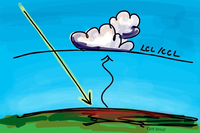
Why Are Clouds Flat At The Bottom? The primary reason clouds appear flat at their base is due to a phenomenon known as the lifting condensation level (LCL) or convective condensation level (CCL). This level represents the altitude at which rising air cools to its dew point temperature, causing water vapor to condense and form cloud droplets.
1.1. The Role of Rising Air
During the day, the sun heats the Earth’s surface, which in turn warms the air near the ground. This warm air is less dense than the surrounding cooler air, causing it to rise. As the warm air rises, it expands and cools due to the decrease in atmospheric pressure. This process is known as adiabatic cooling.
1.2. Condensation and the Lifting Condensation Level
As the rising air cools, it eventually reaches a point where it becomes saturated with water vapor. This saturation point is known as the dew point temperature. When the air reaches its dew point, the water vapor in the air condenses into liquid water droplets. These droplets then coalesce to form clouds.
The altitude at which this condensation occurs is the lifting condensation level (LCL). Because the conditions for condensation are relatively uniform at this level, clouds tend to form a flat base. This is why many cumulus clouds, in particular, have a distinct flat bottom.
1.3. Factors Affecting the Lifting Condensation Level
The height of the lifting condensation level is influenced by two main factors:
- Temperature: Warmer air can hold more moisture than cooler air. Therefore, the warmer the air near the ground, the higher it needs to rise and cool before it reaches its dew point temperature.
- Humidity: Higher humidity means there is more water vapor in the air. With more moisture available, the air does not need to rise as high to become saturated, resulting in a lower lifting condensation level.
In summary, clouds have flat bottoms because they form at the altitude where the rising air reaches its dew point temperature, causing water vapor to condense. This level is influenced by temperature and humidity, making it a relatively uniform altitude that results in the characteristic flat cloud base.
2. Deep Dive into Atmospheric Processes
To fully understand why clouds are flat at the bottom, it is essential to delve deeper into the atmospheric processes that govern cloud formation. These processes include the concepts of adiabatic cooling, dew point, and the interplay between temperature and humidity.
2.1. Adiabatic Cooling Explained
Adiabatic cooling refers to the process by which air cools as it rises and expands, without any heat being added or removed from the system. This cooling occurs because the air parcel is doing work to expand against the lower atmospheric pressure at higher altitudes.
The rate at which air cools as it rises is known as the adiabatic lapse rate. There are two types of adiabatic lapse rates:
- Dry Adiabatic Lapse Rate (DALR): This rate applies to unsaturated air and is approximately 9.8°C per kilometer (5.5°F per 1,000 feet).
- Saturated Adiabatic Lapse Rate (SALR): This rate applies to saturated air (air that is at its dew point) and is typically lower than the DALR, ranging from 4°C to 9°C per kilometer (2.2°F to 4.9°F per 1,000 feet). The SALR is lower because condensation releases latent heat, which partially offsets the cooling due to expansion.
2.2. Dew Point and Saturation
The dew point is the temperature to which air must be cooled at constant pressure to become saturated with water vapor. At the dew point, the air can hold no more moisture in the gaseous state. Any further cooling will result in condensation.
The dew point is a crucial factor in cloud formation because it determines the altitude at which condensation will begin. When the rising air reaches its dew point, water vapor condenses into liquid water droplets, forming clouds.
2.3. The Interplay of Temperature and Humidity
Temperature and humidity are closely related and play a significant role in determining the lifting condensation level. Warmer air can hold more moisture than cooler air, which means that the dew point temperature will be higher when the air is warmer. Conversely, cooler air can hold less moisture, resulting in a lower dew point temperature.
Humidity refers to the amount of water vapor present in the air. It is often expressed as relative humidity, which is the percentage of water vapor in the air compared to the maximum amount of water vapor the air can hold at a given temperature. When the relative humidity is 100%, the air is saturated, and the dew point temperature is equal to the actual air temperature.
The relationship between temperature and humidity can be summarized as follows:
- High Temperature, High Humidity: The air can hold a lot of moisture, and there is a lot of moisture present. The lifting condensation level will be relatively low.
- High Temperature, Low Humidity: The air can hold a lot of moisture, but there is not much moisture present. The lifting condensation level will be relatively high.
- Low Temperature, High Humidity: The air cannot hold much moisture, but there is a lot of moisture present. The lifting condensation level will be relatively low.
- Low Temperature, Low Humidity: The air cannot hold much moisture, and there is not much moisture present. The lifting condensation level will be relatively high.
2.4. Research Insights
According to research from the University of California, Berkeley, atmospheric scientists have developed advanced models to predict the lifting condensation level with high accuracy. These models take into account various factors, including temperature profiles, humidity levels, and atmospheric pressure.
These models have shown that the lifting condensation level can vary significantly depending on the location and time of year. For example, in tropical regions with high humidity, the lifting condensation level is often very low, resulting in clouds that form close to the ground. In contrast, in arid regions with low humidity, the lifting condensation level can be quite high, leading to clouds that form at higher altitudes.
3. Types of Clouds and Their Formation Altitudes
Clouds are classified based on their altitude and appearance. Understanding the different types of clouds and their typical formation altitudes can provide further insight into why some clouds have flat bottoms while others do not.
3.1. High Clouds
High clouds form at altitudes above 6,000 meters (20,000 feet) and are composed primarily of ice crystals due to the cold temperatures at these altitudes. The main types of high clouds include:
- Cirrus (Ci): Thin, wispy clouds that often appear as delicate streaks or patches in the sky.
- Cirrocumulus (Cc): Small, white patches of clouds arranged in regular patterns, often resembling ripples or grains.
- Cirrostratus (Cs): Thin, sheet-like clouds that often cover the entire sky and can cause a halo effect around the sun or moon.
Because high clouds form at such high altitudes, they are not typically associated with flat bottoms. Instead, their appearance is often determined by the prevailing winds and atmospheric conditions at these altitudes.
3.2. Middle Clouds
Middle clouds form at altitudes between 2,000 and 6,000 meters (6,500 and 20,000 feet) and are composed of a mixture of water droplets and ice crystals. The main types of middle clouds include:
- Altocumulus (Ac): Patches of puffy clouds arranged in sheets or layers, often with a rippled or wave-like appearance.
- Altostratus (As): Gray or bluish-gray sheets of clouds that often cover the entire sky. They are typically thicker and more uniform than cirrostratus clouds.
Middle clouds can sometimes exhibit flat bottoms, particularly when they form in stable atmospheric conditions. However, their appearance is often more variable than low clouds.
3.3. Low Clouds
Low clouds form at altitudes below 2,000 meters (6,500 feet) and are composed primarily of water droplets. The main types of low clouds include:
- Stratus (St): Gray, uniform sheets of clouds that often cover the entire sky. They can produce drizzle or light rain.
- Stratocumulus (Sc): Patches of lumpy or rounded clouds arranged in sheets or layers. They are often darker and more well-defined than altocumulus clouds.
- Cumulus (Cu): Detached, puffy clouds with flat bases and distinct outlines. They are often described as having a cotton-like appearance.
Cumulus clouds are the most common type of cloud to exhibit flat bottoms due to their formation at the lifting condensation level. The flat base of cumulus clouds is a clear visual indicator of the altitude at which the rising air has cooled to its dew point and condensation has begun.
3.4. Vertical Clouds
Vertical clouds, also known as cumulonimbus clouds, are towering clouds that can extend throughout the troposphere, from near the ground to altitudes of 12,000 meters (40,000 feet) or higher. These clouds are associated with thunderstorms and severe weather.
Cumulonimbus clouds have a characteristic flat top, known as an anvil, which forms when the rising air reaches the tropopause, the boundary between the troposphere and the stratosphere. The tropopause acts as a cap, preventing the cloud from rising any further and causing it to spread out horizontally.
4. The Tropopause and Flat Cloud Tops
While the lifting condensation level explains why clouds have flat bottoms, the tropopause explains why some clouds have flat tops. The tropopause is the boundary between the troposphere and the stratosphere, and it plays a crucial role in determining the vertical extent of clouds.
4.1. Understanding the Tropopause
The tropopause is the region in the atmosphere where the temperature stops decreasing with height and begins to increase. This temperature inversion acts as a cap, preventing rising air from penetrating into the stratosphere.
The height of the tropopause varies depending on latitude and time of year. It is typically higher in the tropics (around 16-18 kilometers or 52,000-59,000 feet) and lower at the poles (around 8-10 kilometers or 26,000-33,000 feet). It is also higher in the summer and lower in the winter.
4.2. How the Tropopause Creates Flat Cloud Tops
When a cumulonimbus cloud rises through the troposphere, it eventually reaches the tropopause. The rising air is no longer able to rise because it is blocked by the warmer, more stable air in the stratosphere. This causes the cloud to spread out horizontally, forming the characteristic flat top or anvil shape.
The anvil shape is created by the strong upper-level winds that blow the ice crystals and water droplets downwind. The anvil can extend for hundreds of kilometers and is a clear indication of a mature thunderstorm.
4.3. Examples of Clouds with Flat Tops
Cumulonimbus clouds are the most common type of cloud to exhibit flat tops due to the tropopause. However, other types of clouds can also have flat tops under certain conditions. For example, lenticular clouds, which form when air flows over mountains, can sometimes have flat tops due to the stable atmospheric conditions at the altitude where they form.
5. Practical Applications of Cloud Knowledge
Understanding cloud formation and the factors that influence cloud appearance has numerous practical applications in fields such as meteorology, aviation, and climate science.
5.1. Weather Forecasting
Meteorologists use cloud observations to help forecast weather conditions. The type, altitude, and appearance of clouds can provide valuable information about the stability of the atmosphere, the presence of moisture, and the potential for precipitation.
For example, the presence of cumulus clouds with flat bottoms indicates a stable atmosphere with rising air. If the cumulus clouds start to grow vertically, it could be a sign that thunderstorms are developing. The appearance of altostratus clouds can indicate an approaching storm system, while cirrus clouds can signal a change in weather conditions.
5.2. Aviation
Pilots rely on cloud observations to make informed decisions about flight planning and navigation. Clouds can affect visibility, turbulence, and icing conditions, all of which can impact the safety and efficiency of flights.
Pilots use cloud information to avoid flying through thunderstorms, which can cause severe turbulence and hail. They also use cloud information to plan routes that minimize exposure to icing conditions, which can reduce lift and increase drag on the aircraft.
5.3. Climate Science
Clouds play a crucial role in the Earth’s climate system. They reflect incoming solar radiation back into space, which cools the planet. They also trap outgoing infrared radiation, which warms the planet. The balance between these two effects determines the net impact of clouds on the Earth’s climate.
Climate scientists study clouds to understand how they are changing in response to global warming. Changes in cloud cover, altitude, and type can have significant impacts on the Earth’s temperature and precipitation patterns.
5.4. Impact of Aerosols on Cloud Formation
Aerosols, tiny particles suspended in the air, can also affect cloud formation. Aerosols act as cloud condensation nuclei (CCN), providing a surface for water vapor to condense upon. The presence of aerosols can increase the number of cloud droplets, which can make clouds brighter and more reflective.
However, aerosols can also suppress precipitation by reducing the size of cloud droplets. Smaller droplets are less likely to collide and coalesce into larger raindrops, which can delay or prevent rainfall.
According to a study by the National Oceanic and Atmospheric Administration (NOAA), human activities have significantly increased the concentration of aerosols in the atmosphere, particularly in urban and industrial areas. This increase in aerosols has had a complex and uncertain impact on cloud formation and climate.
6. Delving into Cloud Dynamics
Understanding why clouds are flat at the bottom also involves delving into cloud dynamics. Cloud dynamics refers to the study of the motions and processes within clouds that govern their formation, evolution, and dissipation.
6.1. Convection and Cloud Formation
Convection is a primary mechanism for cloud formation. Convection occurs when warm, moist air rises from the surface, cools, and condenses to form clouds. The strength of the convection depends on the temperature and humidity of the air, as well as the stability of the atmosphere.
When the atmosphere is unstable, warm air can rise rapidly, leading to the formation of towering cumulonimbus clouds. When the atmosphere is stable, warm air rises more slowly, resulting in the formation of shallow cumulus clouds or stratus clouds.
6.2. Turbulence and Cloud Mixing
Turbulence plays a crucial role in mixing air within clouds. Turbulence is caused by wind shear, temperature gradients, and other factors. It can enhance cloud formation by bringing more moisture into the cloud and can also dissipate clouds by mixing dry air into the cloud.
Turbulence can also affect the shape and appearance of clouds. Strong turbulence can cause clouds to become more irregular and ragged, while weak turbulence can allow clouds to maintain their shape and structure.
6.3. Cloud Feedback Mechanisms
Clouds can also influence the environment in which they form. For example, clouds can shade the surface, reducing the amount of solar radiation that reaches the ground. This can cool the surface and reduce the amount of convection, which can suppress cloud formation.
Clouds can also release precipitation, which can moisten the surface and increase the amount of evaporation. This can increase the amount of moisture in the air, which can enhance cloud formation. These feedback mechanisms can make it difficult to predict how clouds will respond to changes in the environment.
6.4. The Role of Cloud Seeding
Cloud seeding is a technique that attempts to modify the amount or type of precipitation from clouds by dispersing substances into the air that serve as cloud condensation or ice nuclei. The most common chemicals used for cloud seeding include silver iodide and dry ice.
Cloud seeding is often used in areas that are experiencing drought or water shortages. However, the effectiveness of cloud seeding is still a subject of debate among scientists. Some studies have shown that cloud seeding can increase precipitation by a small amount, while other studies have found no significant effect.
7. The Science of Cloud Observation
Observing and studying clouds is an essential part of understanding weather and climate. There are various techniques and tools used to observe clouds, ranging from simple visual observations to sophisticated satellite imagery.
7.1. Visual Cloud Observation
Visual cloud observation is the simplest and most direct way to study clouds. It involves observing the type, altitude, and appearance of clouds and recording this information in a systematic way.
Visual cloud observations can be used to track the movement of weather systems, to assess the stability of the atmosphere, and to predict the potential for precipitation. They can also be used to verify the accuracy of weather forecasts.
7.2. Weather Balloons
Weather balloons are used to measure temperature, humidity, and wind speed at different altitudes in the atmosphere. These measurements can be used to create a vertical profile of the atmosphere, which can be used to assess the stability of the atmosphere and to predict the formation of clouds.
Weather balloons are typically launched twice a day from weather stations around the world. The data collected by weather balloons is used to create weather forecasts and climate models.
7.3. Radar
Radar is used to detect precipitation and to measure its intensity. Radar works by emitting radio waves that are reflected by raindrops, snowflakes, and hailstones. The strength of the reflected signal is proportional to the intensity of the precipitation.
Radar can be used to track the movement of storms, to estimate the amount of rainfall, and to issue warnings for severe weather.
7.4. Satellites
Satellites provide a comprehensive view of clouds from space. Satellites can measure the type, altitude, and extent of clouds, as well as their temperature and reflectivity. This information can be used to create weather forecasts, to monitor climate change, and to study the Earth’s energy balance.
There are two main types of weather satellites: geostationary satellites, which orbit the Earth at the same rate as the Earth’s rotation, and polar-orbiting satellites, which orbit the Earth from pole to pole. Geostationary satellites provide continuous coverage of a specific region, while polar-orbiting satellites provide global coverage.
8. Why Flat Bottoms Matter: Impact on Weather Patterns
The flat bottoms of clouds, particularly cumulus clouds, have a direct impact on local weather patterns. Their presence and characteristics can tell us a lot about the atmosphere’s stability and potential for precipitation.
8.1. Indicators of Atmospheric Stability
Flat-bottomed cumulus clouds often indicate a stable atmosphere. This means that the air is not rising rapidly, and there is less likelihood of severe weather. However, if these clouds start to grow vertically, it may indicate increasing instability and a potential for thunderstorms.
8.2. Predicting Precipitation
The height of the flat cloud base can also provide information about the likelihood of precipitation. A lower cloud base suggests higher humidity and a greater chance of rain. Conversely, a higher cloud base suggests drier conditions.
8.3. Influence on Temperature
Clouds with flat bottoms can also influence local temperatures. During the day, they can provide shade, which cools the surface. At night, they can trap heat, which warms the surface. This can moderate temperature extremes and create a more stable environment.
8.4. Case Studies
- Florida’s Afternoon Thunderstorms: In Florida, cumulus clouds with flat bottoms are common in the afternoon due to the warm, humid air rising from the land and sea. If these clouds grow tall enough, they can develop into thunderstorms, bringing heavy rain and lightning.
- California’s Marine Layer: Along the California coast, a layer of stratus clouds with flat bottoms often forms due to the cool, moist air coming off the Pacific Ocean. This marine layer can keep temperatures cool and create foggy conditions.
9. Debunking Cloud Myths
There are several common myths about clouds that are worth debunking. Understanding the science behind cloud formation can help dispel these misconceptions.
9.1. Myth: All Clouds Produce Rain
Not all clouds produce rain. Clouds must contain enough water droplets or ice crystals that are large enough to fall to the ground as precipitation. Thin, wispy clouds like cirrus clouds do not contain enough moisture to produce rain.
9.2. Myth: Clouds Are Weightless
Clouds are not weightless. They are composed of water droplets or ice crystals, which have mass. However, the individual droplets or crystals are so small that they are suspended in the air by updrafts.
9.3. Myth: Cloud Seeding Can Solve Droughts
Cloud seeding is not a guaranteed solution for droughts. It can only increase precipitation if there are already clouds present in the atmosphere. It cannot create clouds out of thin air.
9.4. Myth: Chemtrails Are Real
The chemtrail conspiracy theory claims that the trails left behind by airplanes are actually chemicals being sprayed into the atmosphere for nefarious purposes. However, there is no scientific evidence to support this claim. The trails are simply condensation trails (contrails) formed by water vapor in the exhaust of jet engines.
10. Further Exploration: Resources and Learning Tools
If you’re interested in learning more about clouds and weather, there are many resources and learning tools available.
10.1. Online Resources
- WHY.EDU.VN: Visit our website for more in-depth explanations and answers to your questions about weather and climate. Our experts are here to provide accurate and reliable information.
- National Weather Service (NWS): The NWS website provides weather forecasts, warnings, and educational resources.
- National Oceanic and Atmospheric Administration (NOAA): The NOAA website offers information about climate, oceans, and atmosphere.
- University Atmospheric Science Departments: Many universities have atmospheric science departments that offer online courses, research papers, and educational materials.
10.2. Books
- “The Cloud Book” by Richard Hamblyn: A comprehensive guide to cloud identification and formation.
- “Weather for Dummies” by John Cox: A beginner-friendly introduction to weather science.
- “Meteorology Today” by C. Donald Ahrens and Robert Henson: A textbook covering all aspects of meteorology.
10.3. Mobile Apps
- CloudSpotter: An app that helps you identify clouds and learn about their characteristics.
- MyRadar: A weather radar app that provides real-time weather information.
- Weather Underground: A comprehensive weather app with detailed forecasts and observations.
FAQ: Frequently Asked Questions About Clouds
To further clarify the topic, here are some frequently asked questions about clouds and their formation.
1. Why do some clouds appear dark?
Clouds appear dark when they are thick enough to block sunlight from passing through. The thicker the cloud, the less light that can penetrate, making it appear darker.
2. How do clouds affect the temperature on Earth?
Clouds have a complex effect on Earth’s temperature. They reflect incoming sunlight, which cools the planet. They also trap outgoing heat, which warms the planet. The net effect depends on the type, altitude, and coverage of the clouds.
3. What are the different types of precipitation that can fall from clouds?
The different types of precipitation include rain, snow, sleet, and hail. The type of precipitation depends on the temperature of the atmosphere.
4. How do contrails form?
Contrails are condensation trails formed by water vapor in the exhaust of jet engines. The water vapor condenses into ice crystals, which form a visible trail in the sky.
5. Can humans control the weather?
Humans can influence the weather to a limited extent through techniques like cloud seeding. However, we cannot control the weather in a significant way.
6. Why are some clouds associated with thunderstorms?
Cumulonimbus clouds are associated with thunderstorms because they are formed by strong updrafts of warm, moist air. These updrafts can create the conditions necessary for lightning, heavy rain, and hail.
7. How do mountains affect cloud formation?
Mountains can affect cloud formation by forcing air to rise. As the air rises, it cools and condenses, forming clouds. This is known as orographic lift.
8. What is a lenticular cloud?
A lenticular cloud is a lens-shaped cloud that forms when air flows over mountains. These clouds are often smooth and have a distinctive appearance.
9. How do clouds contribute to the water cycle?
Clouds are an essential part of the water cycle. They transport water from one location to another and release it as precipitation.
10. Where can I learn more about weather and climate?
You can learn more about weather and climate from various sources, including WHY.EDU.VN, the National Weather Service, NOAA, and university atmospheric science departments.
Conclusion
Understanding why clouds are flat at the bottom requires knowledge of atmospheric processes such as adiabatic cooling, dew point, and the lifting condensation level. These concepts help explain the formation of clouds and their characteristic shapes. By exploring these phenomena, we gain a deeper appreciation for the complexities of our atmosphere and the beauty of the natural world.
For more in-depth explanations and answers to all your questions about weather and other fascinating topics, visit WHY.EDU.VN. Our team of experts is dedicated to providing accurate and reliable information to satisfy your curiosity. Don’t hesitate to reach out and ask your questions today.
Address: 101 Curiosity Lane, Answer Town, CA 90210, United States
Whatsapp: +1 (213) 555-0101
Website: WHY.EDU.VN
Let why.edu.vn be your trusted resource for answering all your burning questions. We’re here to help you explore the world around you and understand the science behind it all.