Why Does A Tornado Happen? Tornadoes, nature’s most violent storms, are a fascinating yet destructive phenomenon. At WHY.EDU.VN, we aim to provide you with a comprehensive understanding of tornado formation, exploring the atmospheric conditions and physical processes that lead to these powerful weather events, along with safety measures to protect yourself and your loved ones. Explore weather patterns, atmospheric science and storm chasing insights.
1. Understanding Tornado Formation: The Essential Ingredients
Tornadoes are not random acts of nature. They require a specific set of atmospheric conditions to come into being. Understanding these ingredients is crucial to comprehending why a tornado happens.
1.1. Instability: The Fuel for the Storm
Instability refers to the condition of the atmosphere when warm, moist air is near the surface and cooler, drier air is aloft. This creates a situation where the warm air wants to rise, like a hot air balloon. This rising air can lead to the formation of thunderstorms, which are the parent storms of tornadoes. The greater the difference in temperature between the surface air and the air aloft, the more unstable the atmosphere and the stronger the potential for severe thunderstorms.
1.2. Wind Shear: The Force That Twists
Wind shear is a change in wind speed and/or direction with height. This change can create rotation in the atmosphere. There are two main types of wind shear:
- Speed Shear: Occurs when the wind speed increases with height.
- Directional Shear: Occurs when the wind direction changes with height.
Both types of wind shear can contribute to the formation of tornadoes. Wind shear creates a horizontal spinning effect in the lower atmosphere. This horizontal rotation can then be tilted vertically by strong updrafts in a thunderstorm, leading to the formation of a rotating column of air known as a mesocyclone.
1.3. The Role of Supercells: The Tornado’s Preferred Environment
While any thunderstorm can potentially produce a tornado, the most common type of storm associated with tornadoes is the supercell. A supercell is a severe, long-lived thunderstorm characterized by a rotating updraft called a mesocyclone. The mesocyclone is a key feature in the formation of tornadoes.
Supercells develop in environments with significant instability and wind shear. The rotating updraft of the mesocyclone can intensify and stretch vertically, eventually forming a tornado that touches the ground. Supercells are capable of producing strong to violent tornadoes and can last for several hours, sometimes producing multiple tornadoes.
2. The Genesis of a Tornado: A Step-by-Step Explanation
Now that we know the ingredients, let’s delve into the step-by-step process of why a tornado happens.
2.1. Formation of a Mesocyclone
The first step in tornado formation is the development of a mesocyclone within a supercell thunderstorm. As mentioned earlier, wind shear creates a horizontal spinning effect in the lower atmosphere. This horizontal rotation is then tilted vertically by the strong updraft of the thunderstorm.
2.2. Intensification and Stretching
Once the mesocyclone is formed, it can begin to intensify and stretch vertically. This is due to the conservation of angular momentum. As the rotating column of air is stretched vertically, it spins faster. This intensification can lead to the formation of a tighter, more concentrated vortex.
2.3. Formation of a Wall Cloud
As the mesocyclone intensifies, a wall cloud may form. A wall cloud is a lowered, rotating cloud base that forms beneath the mesocyclone. It is an indication that the mesocyclone is strengthening and that a tornado may be imminent. The wall cloud forms as moist air is drawn into the rotating mesocyclone and cools, causing condensation.
2.4. Formation of a Funnel Cloud
If the pressure inside the rotating column of air drops low enough, a funnel cloud may form. A funnel cloud is a visible condensation funnel that extends from the base of the thunderstorm. It is formed by water vapor condensing as the air cools and expands in the low-pressure environment of the rotating vortex.
2.5. Touchdown: The Tornado
A tornado is formed when the funnel cloud touches the ground. Once the rotating column of air makes contact with the surface, it is officially classified as a tornado. The tornado then begins to inflict damage as it moves across the landscape.
Alt Text: Diagram illustrating the stages of tornado formation, from mesocyclone development to funnel cloud touchdown, highlighting the role of wind shear and updrafts.
3. Tornado Intensity: The Enhanced Fujita Scale
Tornadoes are classified based on the damage they cause using the Enhanced Fujita (EF) Scale. This scale was introduced in 2007 to replace the original Fujita Scale, which was developed in 1971. The EF Scale is based on the estimated wind speeds of the tornado and the type of damage it causes to various structures.
| EF Rating | Estimated Wind Speed (mph) | Typical Damage |
|---|---|---|
| EF0 | 65-85 | Minor damage, such as broken branches, damaged signs, and shallow-rooted trees pushed over. |
| EF1 | 86-110 | Moderate damage, such as loss of roof surfaces, mobile homes overturned, and exterior doors lost. |
| EF2 | 111-135 | Considerable damage, such as roofs torn off well-constructed houses, mobile homes demolished, and large trees snapped or uprooted. |
| EF3 | 136-165 | Severe damage, such as entire stories of well-constructed houses destroyed, significant damage to large buildings such as shopping malls, and trains overturned. |
| EF4 | 166-200 | Devastating damage, such as well-constructed houses leveled, structures blown considerable distances, and cars thrown. |
| EF5 | Over 200 | Incredible damage, such as strong frame houses lifted off foundations and carried considerable distances, automobile-sized missiles fly through the air in excess of 100 meters, high-rise buildings with significant structural deformation. |
The EF Scale is a valuable tool for assessing the intensity of tornadoes and understanding the potential for damage.
4. Where Do Tornadoes Occur? Tornado Alley and Beyond
While tornadoes can occur in many parts of the world, they are most frequent in the United States, particularly in a region known as “Tornado Alley”.
4.1. Tornado Alley: The Heart of Tornado Activity
Tornado Alley is a loosely defined area of the central United States where tornadoes are most frequent. It typically includes parts of Texas, Oklahoma, Kansas, Nebraska, South Dakota, Iowa, Missouri, Arkansas, and Louisiana. This region is particularly prone to tornadoes due to its unique geography and climate. Warm, moist air from the Gulf of Mexico meets cold, dry air from Canada and the Rocky Mountains, creating the unstable atmospheric conditions necessary for tornado formation.
4.2. Beyond Tornado Alley: Other Tornado-Prone Regions
While Tornado Alley is the most well-known region for tornadoes, they can occur in other parts of the world as well. Some other tornado-prone regions include:
- Dixie Alley: Located in the southeastern United States, including states like Alabama, Mississippi, Tennessee, and Kentucky.
- Argentina, Uruguay, and parts of Brazil and Paraguay: This region in South America experiences frequent severe thunderstorms and tornadoes.
- Bangladesh and India: These countries in South Asia are vulnerable to tornadoes due to their climate and geography.
- Australia: Tornadoes occur in various parts of Australia, although they are not as frequent or intense as in the United States.
- Europe: While less frequent and generally weaker than those in the United States, tornadoes do occur in Europe, particularly in countries like the United Kingdom, Germany, and Italy.
4.3. North and Central Georgia Tornado History
Georgia has experienced almost all strengths of tornadoes, ranging from EF-0 to EF-4. Although the state has never experienced an EF-5, it does not mean it can’t happen.
Alt Text: Map displaying the tracks of tornadoes in North and Central Georgia from 1950 to 2014, indicating varying intensities and paths.
5. Factors Contributing to Tornado Formation
Numerous environmental elements influence the development of tornadoes. Understanding these factors is vital for predicting and preparing for these violent weather events.
5.1. The Role of Moisture
Moisture plays a critical role in the formation of tornadoes. Warm, moist air is buoyant and rises rapidly, contributing to the instability needed for thunderstorm development. The moisture also provides the water vapor that condenses to form clouds and precipitation within the storm.
5.2. Temperature Gradients
Significant temperature differences between the surface and upper levels of the atmosphere create instability. When warm, moist air near the surface is overlain by cooler, drier air aloft, the atmosphere becomes unstable. This instability fuels the development of strong updrafts within thunderstorms, which are essential for tornado formation.
5.3. The Importance of Topography
Topography can influence tornado formation by affecting wind patterns and atmospheric stability. For example, the Rocky Mountains can channel air masses and create conditions favorable for severe thunderstorms in the Great Plains. Similarly, the Appalachian Mountains can influence weather patterns in the southeastern United States.
5.4. Jet Stream Influence
The jet stream, a high-altitude wind current, can play a role in tornado formation by providing upper-level support for thunderstorms. The jet stream can enhance wind shear and create a more favorable environment for the development of supercells.
5.5. Cap and Lid
A “cap” or “lid” is a layer of warm air aloft that inhibits the development of thunderstorms. This layer can prevent thunderstorms from forming initially, but if the cap is broken or weakened, it can lead to explosive thunderstorm development and an increased risk of tornadoes.
6. Predicting Tornadoes: The Science of Forecasting
Predicting tornadoes is a complex process that relies on a combination of weather models, radar data, and observational information. Meteorologists use these tools to identify areas where the conditions are favorable for tornado formation.
6.1. Weather Models: A Glimpse into the Future
Weather models are computer simulations of the atmosphere that are used to predict future weather conditions. These models can provide valuable information about the potential for severe thunderstorms and tornadoes. They can forecast temperature, moisture, wind shear, and other factors that are important for tornado formation.
6.2. Doppler Radar: Detecting Rotation
Doppler radar is a type of radar that can detect the motion of objects in the atmosphere, including precipitation and wind. This allows meteorologists to identify areas of rotation within thunderstorms, which can be an indication of a developing tornado. Our WSR-88D Doppler radar can detect the circulation associated with a tornado producing thunderstorm. Once the circulation is identified, a warning is issued. However, Doppler radar is not perfect, because it can only indicate rotation aloft, and does not indicate what may be happening on the ground.
6.3. Storm Spotters: Eyes on the Ground
Storm spotters are volunteers who are trained to observe and report severe weather conditions, including tornadoes. They provide valuable real-time information to meteorologists, which can help improve the accuracy of tornado warnings. Only feedback from someone in the area can confirm whether the radar signature is associated with a tornado.
6.4. The Role of the National Weather Service
The National Weather Service (NWS) is responsible for issuing tornado watches and warnings. A tornado watch means that conditions are favorable for tornadoes to develop in a particular area. A tornado warning means that a tornado has been sighted or indicated by radar and poses an immediate threat to life and property.
7. Tornado Safety: Protecting Yourself and Your Loved Ones
When a tornado threatens, it’s crucial to take immediate action to protect yourself and your loved ones. Here’s a comprehensive guide to tornado safety:
7.1. Understanding Tornado Watches and Warnings
Distinguishing between a tornado watch and a tornado warning is essential. A tornado watch means that conditions are favorable for tornadoes to develop in the specified area. During a watch, stay informed, monitor weather updates, and have a plan ready in case a tornado warning is issued. A tornado warning means a tornado has been sighted or indicated by radar, posing an imminent threat. Seek shelter immediately when a warning is issued.
7.2. Seeking Shelter: Where to Go
- Underground Shelter: The safest place to be during a tornado is in an underground shelter, such as a basement or storm cellar.
- Interior Room: If an underground shelter is not available, move to a small, windowless interior room or hallway on the lowest level of a sturdy building.
- Abandon Mobile Homes: Mobile homes are particularly vulnerable to tornadoes and should be abandoned immediately. Seek shelter in a nearby sturdy building.
7.3. What to Do If Caught Outdoors
If you are caught outdoors and a sturdy building is not available, there are a few options:
- Vehicle: Immediately get into a vehicle, buckle your seat belt, and try to drive to the closest sturdy shelter.
- Ditch: If flying debris occurs while you are driving, pull over and park. If you can safely get noticeably lower than the level of the roadway, exit your car, and lie in that area, covering your head with your hands.
- Stay in your vehicle: Stay in your vehicle with the seat belt on. Put your head down below the windows, covering it with your hands and a blanket if possible.
7.4. Creating a Tornado Safety Plan
Having a well-thought-out tornado safety plan is crucial for ensuring your safety and the safety of your loved ones. Your plan should include:
- Identifying a safe place to take shelter.
- Establishing a communication plan to stay in touch with family members.
- Assembling a disaster kit with essential supplies.
- Practicing your plan regularly.
7.5. Additional Safety Tips
- Stay Informed: Monitor weather updates through reliable sources such as the National Weather Service, local news, and weather apps.
- Know the Signs: Be aware of the visual cues that may indicate a tornado, such as a dark or greenish sky, large hail, a loud roar or rumble, and a visible rotating cloud.
- Protect Your Head: Always protect your head and neck with your arms or a blanket during a tornado.
- After the Tornado: After the tornado has passed, check for injuries and damage. Be cautious of downed power lines and other hazards.
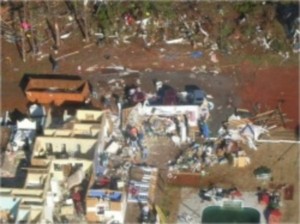 Coweta County Tornado Damage
Alt Text: Image showing the extensive damage caused by a tornado in Coweta County, emphasizing the importance of seeking shelter in an interior room.
8. The Science Behind Tornadoes: Advanced Concepts
For those interested in delving deeper into the science behind tornadoes, here are some more advanced concepts:
8.1. Vorticity and Convergence
Vorticity is a measure of the rotation of air. Convergence is the coming together of air masses. Both vorticity and convergence are important for tornado formation. Convergence can increase vorticity by concentrating the rotation into a smaller area.
8.2. Baroclinic Instability
Baroclinic instability is a type of atmospheric instability that can lead to the development of mid-latitude cyclones and severe thunderstorms. It is caused by temperature gradients and wind shear.
8.3. The Role of Downdrafts
Downdrafts are descending currents of air within a thunderstorm. They can play a role in tornado formation by helping to concentrate vorticity near the surface.
8.4. Numerical Weather Prediction (NWP)
Numerical weather prediction (NWP) is the use of computer models to forecast future weather conditions. NWP models are becoming increasingly sophisticated and are able to predict severe weather events, including tornadoes, with greater accuracy.
9. Famous Tornado Outbreaks in History
Throughout history, there have been several notable tornado outbreaks that have caused significant damage and loss of life. Some of the most famous include:
| Outbreak | Date | Description |
|---|---|---|
| The Tri-State Tornado | March 18, 1925 | One of the deadliest tornadoes in U.S. history, traveling over 200 miles through Missouri, Illinois, and Indiana. |
| The Super Outbreak | April 3-4, 1974 | A massive outbreak of 148 tornadoes across 13 states in the eastern United States. |
| The Oklahoma City Tornado | May 3, 1999 | A powerful F5 tornado that struck Oklahoma City, causing widespread damage and loss of life. |
| The April 2011 Super Outbreak | April 25-28, 2011 | A historic outbreak of 362 tornadoes across 21 states, resulting in over 300 fatalities. |
| Palm Sunday Tornadoes of March 27,1994 | March 27, 1994 | A major supercell outbreaks in north or central Georgia. |
| Southeast Tornado Outbreak | April 27-28, 2011 | A major supercell outbreaks in north or central Georgia. |
These outbreaks serve as reminders of the destructive potential of tornadoes and the importance of being prepared.
10. The Future of Tornado Research and Prediction
Tornado research and prediction are ongoing areas of scientific study. Scientists are working to improve our understanding of tornado formation and to develop more accurate forecasting tools.
10.1. Improving Weather Models
One area of research is focused on improving weather models. Scientists are working to incorporate more detailed information about the atmosphere into models, such as data from weather satellites and radar.
10.2. Studying Tornado Dynamics
Another area of research is focused on studying the dynamics of tornadoes. Scientists are using advanced techniques, such as Doppler radar and computer simulations, to learn more about the processes that lead to tornado formation and intensification.
10.3. Enhancing Warning Systems
Efforts are also underway to enhance tornado warning systems. This includes developing more effective ways to communicate warnings to the public and improving the accuracy of tornado forecasts.
10.4. VORTEX-SE Project
The Verification of the Origins of Rotation in Tornadoes Experiment-Southeast (VORTEX-SE) is a research project focused on studying tornadoes in the southeastern United States. The project aims to improve our understanding of tornado formation in this region, which is particularly vulnerable to tornadoes.
FAQ: Frequently Asked Questions About Tornadoes
Here are some frequently asked questions about tornadoes:
- What is a tornado? A tornado is a violently rotating column of air that extends from a thunderstorm to the ground.
- How do tornadoes form? Tornadoes form from severe thunderstorms in unstable atmospheric conditions with wind shear.
- What is Tornado Alley? Tornado Alley is a region in the central United States where tornadoes are most frequent.
- What is the Enhanced Fujita (EF) Scale? The EF Scale is used to rate the intensity of tornadoes based on the damage they cause.
- What should I do during a tornado watch? During a tornado watch, stay informed, monitor weather updates, and have a plan ready in case a tornado warning is issued.
- What should I do during a tornado warning? During a tornado warning, seek shelter immediately in an underground shelter, interior room, or sturdy building.
- What is a supercell thunderstorm? A supercell is a severe thunderstorm with a rotating updraft called a mesocyclone.
- Can tornadoes occur at night? Yes, tornadoes can occur at any time of day or night.
- What is a wall cloud? A wall cloud is a lowered, rotating cloud base beneath a thunderstorm that may indicate a developing tornado.
- How can I stay safe during a tornado? Stay informed, have a safety plan, seek shelter immediately when a warning is issued, and protect your head and neck.
Conclusion: The Power and Peril of Tornadoes
Tornadoes are powerful and dangerous weather events that can cause significant damage and loss of life. Understanding why a tornado happens is essential for protecting yourself and your loved ones. By learning about the atmospheric conditions that lead to tornado formation, the warning signs of a tornado, and the safety measures you can take, you can be better prepared to face this threat.
At WHY.EDU.VN, we understand that finding reliable answers to complex questions can be challenging. That’s why we’re dedicated to providing you with accurate, easy-to-understand explanations on a wide range of topics. Whether you’re curious about weather phenomena like tornadoes, or have questions about science, history, or anything in between, we’re here to help.
Do you have more questions about tornadoes or any other topic? Visit WHY.EDU.VN at 101 Curiosity Lane, Answer Town, CA 90210, United States or contact us via WhatsApp at +1 (213) 555-0101 to ask your questions and connect with experts. We are committed to providing you with the answers you seek, fostering a community of informed and engaged learners. Don’t let your curiosity wait – explore why.edu.vn today and discover the answers you’ve been searching for.